
Oaxaca topographic map
Interactive map
Click on the map to display elevation.
Oaxaca
The state is located in the south of Mexico, bordered by the states of Puebla, Veracruz, Chiapas and Guerrero with the Pacific Ocean to the south. It has a territory of 93,967 km2 (36,281 sq mi), accounting for less than 5% of Mexico's territory. Here several mountain chains come together, with the elevation varying from sea level to 3,759 m (12,333 ft) asl, averaging at 1,500 m (4,921 ft) asl. Oaxaca has one of the most rugged terrains in Mexico, with mountain ranges that abruptly fall into the sea. Between these mountains are mostly narrow valleys, canyons and ravines. Major elevations in the state include Zempoaltepetl (3,396 m or 11,142 ft asl), El Espinazo del Diablo, Nindú Naxinda Yucunino and Cerro Encantado. Oaxaca's has 533 km (331 mi) of coastline with nine major bays.
About this map
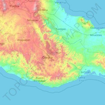
Name: Oaxaca topographic map, elevation, terrain.
Location: Oaxaca, Mexico (15.65688 -98.55270 18.66969 -93.86743)
Average elevation: 714 m
Minimum elevation: -2 m
Maximum elevation: 5,196 m
Other topographic maps
Click on a map to view its topography, its elevation and its terrain.