
Guerrero topographic map
Interactive map
Click on the map to display elevation.
Guerrero
The state's climate is dominated by the rainy tropical areas and rainy temperate areas. The former has high temperatures above 18 °C (64.4 °F) year round and experiences most rain in the summer and early fall. Most of this is found near the coast under 2,000 m (6,562 ft) asl. In the higher elevations away from the coast in the Sierra Madre del Sur, the climate is temperate but also experiences the same pattern of rainfall. Most of the rain that falls in the state is produced from evaporation from the Pacific Ocean.
About this map
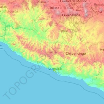
Name: Guerrero topographic map, elevation, terrain.
Location: Guerrero, Mexico (16.31622 -102.18435 18.88785 -98.00728)
Average elevation: 862 m
Minimum elevation: -1 m
Maximum elevation: 5,195 m
Other topographic maps
Click on a map to view its topography, its elevation and its terrain.