
Thank you for supporting this site ❤️
Make a donation
Make a donation
Kallar topographic map
Click on the map to display elevation.
Thank you for supporting this site ❤️
Make a donation
Make a donation
About this map
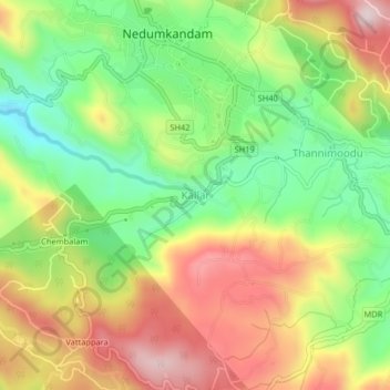
Name: Kallar topographic map, elevation, terrain.
Location: Kallar, Udumbanchola, Idukki, Kerala, 685553, India (9.80480 77.13690 9.84480 77.17690)
Average elevation: 923 m
Minimum elevation: 745 m
Maximum elevation: 1,128 m
Thank you for supporting this site ❤️
Make a donation
Make a donation
Other topographic maps
Click on a map to view its topography, its elevation and its terrain.
Thank you for supporting this site ❤️
Make a donation
Make a donation
Thank you for supporting this site ❤️
Make a donation
Make a donation