
Uttan topographic map
Interactive map
Click on the map to display elevation.
About this map
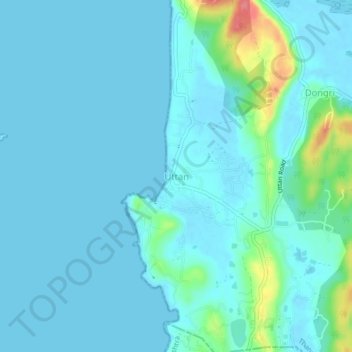
Name: Uttan topographic map, elevation, terrain.
Location: Uttan, Mira-Bhayander, Thane, Maharashtra, 401106, India (19.26161 72.76526 19.30161 72.80526)
Average elevation: 11 m
Minimum elevation: -1 m
Maximum elevation: 85 m
Other topographic maps
Click on a map to view its topography, its elevation and its terrain.
Ghodbunder
India > Maharashtra > Thane > Mira-Bhayander
Ghodbunder, Mira-Bhayander, Thane, Maharashtra, 401107, India
Average elevation: 21 m
Dahisar River
India > Maharashtra > Thane > Mira-Bhayander
Dahisar River, Zone 4, Mira-Bhayander, Mumbai Metropolitan Region, Thane, Mumbai Suburban, Maharashtra, 400068, India
Average elevation: 83 m
Versova
India > Maharashtra > Thane > Mira-Bhayander
Versova, Mira-Bhayander, Thane, Maharashtra, 401104, India
Average elevation: 26 m