
Thank you for supporting this site ❤️
Make a donation
Make a donation
Mayiladuthurai topographic map
Click on the map to display elevation.
Thank you for supporting this site ❤️
Make a donation
Make a donation
About this map
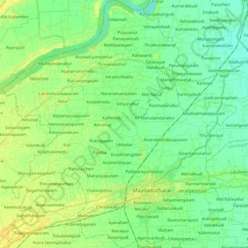
Name: Mayiladuthurai topographic map, elevation, terrain.
Location: Mayiladuthurai, Mayiladuthurai district, Tamil Nadu, India (11.05506 79.52652 11.25527 79.71989)
Average elevation: 10 m
Minimum elevation: 2 m
Maximum elevation: 20 m
Thank you for supporting this site ❤️
Make a donation
Make a donation
Other topographic maps
Click on a map to view its topography, its elevation and its terrain.
Mayiladuthurai
India > Tamil Nadu > Mayiladuthurai
Mayliladuthurai is situated at a distance of 281 kilometres (175 mi) from Chennai and 122 kilometres (76 mi) from Tiruchirappalli. The town is located at 11°06′N 79°39′E / 11.10°N 79.65°E / 11.10; 79.65. Situated at a distance of 24 kilometres (15 mi) from the Bay of Bengal coast, the town is…
Average elevation: 10 m
Thank you for supporting this site ❤️
Make a donation
Make a donation