
Rockland County topographic map
Interactive map
Click on the map to display elevation.
About this map
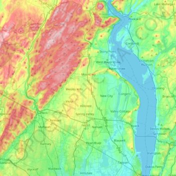
Name: Rockland County topographic map, elevation, terrain.
Location: Rockland County, New York, United States of America (40.99670 -74.23440 41.32138 -73.88916)
Average elevation: 137 m
Minimum elevation: -1 m
Maximum elevation: 425 m
Other topographic maps
Click on a map to view its topography, its elevation and its terrain.
Battery Park City
United States of America > New York > Manhattan Community Board 1
Battery Park City, Manhattan Community Board 1, New York County, New York, United States of America
Average elevation: 5 m
Stony Point
United States of America > New York
Stony Point, Town of Stony Point, Rockland County, New York, 10980, United States of America
Average elevation: 71 m
North Brother Island
United States of America > New York > New York
North Brother Island, The Bronx, Bronx County, New York, United States of America
Average elevation: 4 m
Queens
United States of America > New York
Queens, New York, United States of America
Average elevation: 11 m
Lighthouse Beach
United States of America > New York > Parma Town > Lighthouse Beach
Lighthouse Beach, Parma Town, Monroe, New York, United States of America
Average elevation: 76 m
Ontario County
United States of America > New York
Richmond Town, Ontario County, New York, 14471, United States of America
Average elevation: 399 m
Allegany County
United States of America > New York
Allegany County, New York, United States of America
Average elevation: 561 m
Farmingville
United States of America > New York > Farmingville > Farmingville
Farmingville, Suffolk, New York, 11738, United States of America
Average elevation: 47 m
Rensselaer County
United States of America > New York
Rensselaer County, New York, United States of America
Average elevation: 239 m
Chenango County
United States of America > New York
Chenango County, New York, United States of America
Average elevation: 442 m