
Liscannor topographic map
Interactive map
Click on the map to display elevation.
About this map
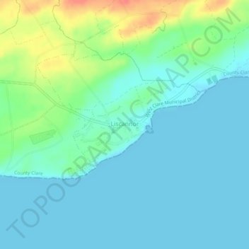
Name: Liscannor topographic map, elevation, terrain.
Average elevation: 13 m
Minimum elevation: 0 m
Maximum elevation: 50 m
Other topographic maps
Click on a map to view its topography, its elevation and its terrain.
Cliffs of Moher
Cliffs of Moher, Ballysteen ED, West Clare Municipal District, County Clare, Munster, Ireland
Average elevation: 55 m