
Spijkenisse topographic map
Interactive map
Click on the map to display elevation.
About this map
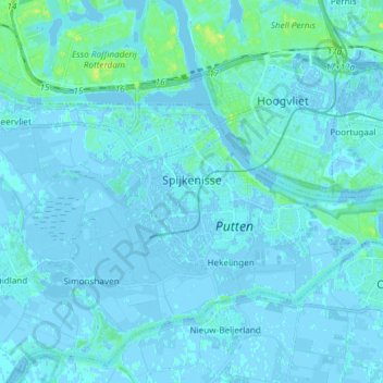
Name: Spijkenisse topographic map, elevation, terrain.
Location: Spijkenisse, Nissewaard, South Holland, Netherlands (51.82247 4.28378 51.86448 4.43248)
Average elevation: 1 m
Minimum elevation: -5 m
Maximum elevation: 16 m
Other topographic maps
Click on a map to view its topography, its elevation and its terrain.
Zoetermeer
Netherlands > South Holland > Zoetermeer
Zoetermeer, South Holland, Netherlands
Average elevation: -3 m
Zwijndrecht
Netherlands > South Holland > Zwijndrecht
Zwijndrecht, South Holland, Netherlands
Average elevation: 1 m
Alphen aan den Rijn
Netherlands > South Holland > Alphen aan den Rijn
Alphen aan den Rijn, South Holland, Netherlands
Average elevation: -2 m