
Teldeniya topographic map
Interactive map
Click on the map to display elevation.
About this map
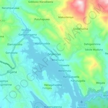
Name: Teldeniya topographic map, elevation, terrain.
Location: Teldeniya, Kandy District, Central Province, 20900, Sri Lanka (7.26964 80.72495 7.34964 80.80495)
Average elevation: 601 m
Minimum elevation: 415 m
Maximum elevation: 1,289 m
Other topographic maps
Click on a map to view its topography, its elevation and its terrain.
Siridigana
Sri Lanka > Central Province > Teldeniya > Siridigana
Siridigana, Teldeniya, Kandy District, Central Province, 20900, Sri Lanka
Average elevation: 658 m