
Central Region topographic map
Interactive map
Click on the map to display elevation.
About this map
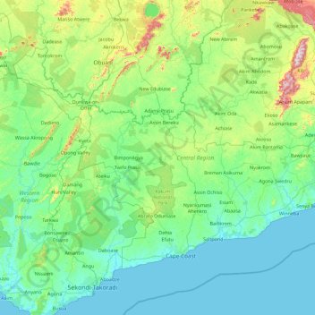
Name: Central Region topographic map, elevation, terrain.
Location: Central Region, Ghana (5.03343 -2.20525 6.29927 -0.40033)
Average elevation: 114 m
Minimum elevation: -1 m
Maximum elevation: 824 m
Other topographic maps
Click on a map to view its topography, its elevation and its terrain.
Akwapim
Ghana > Eastern Region > Yilo-Krobo Municipal District
Akwapim, Yilo-Krobo Municipal District, Eastern Region, Ghana
Average elevation: 384 m
Atiwa West District
Atiwa West District, Eastern Region, Ghana
Average elevation: 265 m
Takoradi
Ghana > Western Region > Sekondi Takoradi Metropolitan District
Takoradi, Sekondi Takoradi Metropolitan District, Western Region, Ghana
Average elevation: 4 m
Accra
Ghana > Greater Accra Region > Korle-Klottey Municipal District
Accra, Korle-Klottey Municipal District, Greater Accra Region, Ghana
Average elevation: 31 m
Goa
Ghana > Ahafo Region > Asunafo North Municipal District > Goaso
Goa, Bobkrom, Goaso, Asunafo North Municipal District, Ahafo Region, BU-0036-9559, Ghana
Average elevation: 189 m
Goa
Ghana > Ahafo Region > Asutifi South District
Goa, Asutifi South District, Ahafo Region, BU-0036-9559, Ghana
Average elevation: 189 m
Kwabeng
Ghana > Eastern Region > Atiwa West District
Kwabeng, Atiwa West District, Eastern Region, Ghana
Average elevation: 215 m
Ningo-Prampram District
Ningo-Prampram District, Greater Accra Region, Ghana
Average elevation: 31 m
Legon
Ghana > Greater Accra Region > Ayawaso West Municipal District > Accra
Legon, Accra, Ayawaso West Municipal District, Greater Accra Region, Ghana
Average elevation: 56 m
Tamale
Ghana > Northern Region > Tamale Metropolitan District > Tamale
Tamale, Tamale Metropolitan District, Northern Region, P.O. BOX 232, Ghana
Average elevation: 151 m
Atua
Ghana > Western North Region > Aowin Municipal District > Enchi
Atua, Zongo, Enchi, Aowin Municipal District, Western North Region, Ghana
Average elevation: 89 m