
Częstochowa topographic map
Interactive map
Click on the map to display elevation.
About this map
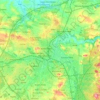
Name: Częstochowa topographic map, elevation, terrain.
Location: Częstochowa, Silesian Voivodeship, Poland (50.73473 19.01125 50.88455 19.23318)
Average elevation: 263 m
Minimum elevation: 227 m
Maximum elevation: 327 m
Other topographic maps
Click on a map to view its topography, its elevation and its terrain.
Bytom
Poland > Silesian Voivodeship > Bytom
Bytom, Górnośląsko-Zagłębiowska Metropolia, Silesian Voivodeship, Poland
Average elevation: 287 m
Katowice
Poland > Silesian Voivodeship > Katowice
Katowice, GZM, Silesian Voivodeship, Poland
Average elevation: 275 m