
Pokaran topographic map
Interactive map
Click on the map to display elevation.
About this map
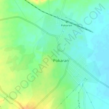
Name: Pokaran topographic map, elevation, terrain.
Location: Pokaran, Pokaran Tehsil, Jaisalmer District, Rajasthan, India (26.90607 71.90272 26.93711 71.92982)
Average elevation: 230 m
Minimum elevation: 218 m
Maximum elevation: 249 m
Surrounded by rocks, sand and five salt ranges, its Hindi name "Pokhran" (पोखरण) means "five salt-ranges". It is located between Jaisalmer and Jodhpur or Bikaner at 27°05′42″N 71°45′11″E / 27.095°N 71.753°E / 27.095; 71.753 and has an average elevation of 233 metres (764 feet).
Other topographic maps
Click on a map to view its topography, its elevation and its terrain.
Bodana
India > Rajasthan > Pokaran Tehsil
Bodana, Pokaran Tehsil, Jaisalmer District, Rajasthan, India
Average elevation: 171 m