
Oakland topographic map
Interactive map
Click on the map to display elevation.
About this map
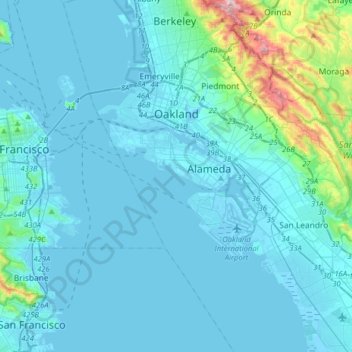
Name: Oakland topographic map, elevation, terrain.
Location: Oakland, Alameda County, California, United States (37.63368 -122.35588 37.88543 -122.11442)
Average elevation: 51 m
Minimum elevation: -11 m
Maximum elevation: 569 m
Other topographic maps
Click on a map to view its topography, its elevation and its terrain.
Emeryville
United States > California > Alameda County
Emeryville, Alameda County, CAL Fire Northern Region, California, 94608, United States
Average elevation: 14 m