
Wells County topographic map
Interactive map
Click on the map to display elevation.
About this map
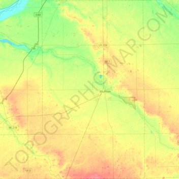
Name: Wells County topographic map, elevation, terrain.
Location: Wells County, Indiana, Vereinigte Staaten von Amerika (40.56632 -85.44903 40.91776 -85.06849)
Average elevation: 255 m
Minimum elevation: 226 m
Maximum elevation: 285 m
Other topographic maps
Click on a map to view its topography, its elevation and its terrain.
Princeton
Vereinigte Staaten von Amerika > Indiana > Princeton
Princeton, Gibson County, Indiana, Vereinigte Staaten von Amerika
Average elevation: 149 m
Rumble
Vereinigte Staaten von Amerika > Indiana > Rumble
Rumble, Pike County, Indiana, Vereinigte Staaten von Amerika
Average elevation: 153 m