
Pico Mucuñuque topographic map
Interactive map
Click on the map to display elevation.
About this map
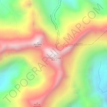
Name: Pico Mucuñuque topographic map, elevation, terrain.
Average elevation: 4,195 m
Minimum elevation: 3,743 m
Maximum elevation: 4,586 m
Other topographic maps
Click on a map to view its topography, its elevation and its terrain.
Laguna de Mucubají
Venezuela > Mérida > Parroquia San Rafael
Laguna de Mucubají, Carretera Barinas - Mérida, Parroquia San Rafael, Municipio Rangel, Mérida, Venezuela
Average elevation: 3,604 m