
Greenland topographic map
Interactive map
Click on the map to display elevation.
About this map
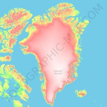
Name: Greenland topographic map, elevation, terrain.
Location: Greenland (59.51539 -74.12504 83.87517 -10.02888)
Average elevation: 594 m
Minimum elevation: -2 m
Maximum elevation: 3,433 m
The lowest temperature ever recorded in the Northern Hemisphere was recorded in Greenland, near the topographic summit of the Greenland Ice Sheet, on 22 December 1991, when the temperature reached −69.6 °C (−93.3 °F). In Nuuk, the average daily temperature varies over the seasons from −5.1 to 9.9 °C (22.8 to 49.8 °F) The total area of Greenland is 2,166,086 km2 (836,330 sq mi) (including other offshore minor islands), of which the Greenland ice sheet covers 1,755,637 km2 (677,855 sq mi) (81%) and has a volume of approximately 2,850,000 km3 (680,000 cu mi). The highest point on Greenland is Gunnbjørn Fjeld at 3,700 m (12,100 ft) of the Watkins Range (East Greenland mountain range). The majority of Greenland, however, is less than 1,500 m (4,900 ft) in elevation.
Other topographic maps
Click on a map to view its topography, its elevation and its terrain.
India
India
Average elevation: 1,017 m
Montreal
Canada > Quebec > Urban agglomeration of Montreal > Montreal
Montreal, Urban agglomeration of Montreal, Montreal (06), Quebec, H3B 1M7, Canada
Average elevation: 30 m
Tacoma
United States > Washington > Pierce County
Tacoma, Pierce County, Washington, United States
Average elevation: 67 m
Sri Lanka
Sri Lanka
Average elevation: 50 m
Hyderabad
India > Telangana > Bahadurpura mandal
Hyderabad, Bahadurpura mandal, Hyderabad District, Telangana, India
Average elevation: 549 m
Bengaluru
India > Karnataka > Bangalore North
Bengaluru, Bangalore North, Bengaluru Urban District, Karnataka, India
Average elevation: 881 m
Kandy
Kandy, Kandy District, Central Province, 20000, Sri Lanka
Average elevation: 621 m
Pune
India > Maharashtra > Pune City > Pune
Pune, Pune City, Pune District, Maharashtra, 411001, India
Average elevation: 641 m
saraikhet
India > Uttarakhand > Dhoomakot
saraikhet, Dhoomakot, Pauri Garhwal District, Uttarakhand, India
Average elevation: 1,861 m
Bhatwari
Bhatwari, Uttarkashi District, Uttarakhand, India
Average elevation: 4,570 m
Chennai
India > Tamil Nadu > Chennai
Chennai, Chennai District, Tamil Nadu, India
Average elevation: 8 m
Dudori
India > Uttarakhand > Syalde > Kaljipa
Dudori, Kaljipa, Syalde, Almora District, Uttarakhand, 263665, India
Average elevation: 1,564 m
Vairavanpatti
India > Tamil Nadu > Thiruppathur
Vairavanpatti, Thiruppathur, Sivagangai District, Tamil Nadu, 630207, India
Average elevation: 103 m
Vadodara
India > Gujarat > Vadodara Taluka
Vadodara, Vadodara Taluka, Vadodara District, Gujarat, 390001, India
Average elevation: 36 m
Surat
India > Gujarat > Katargam Taluka > Surat
Surat, Katargam Taluka, Surat, Gujarat, 395001, India
Average elevation: 11 m
Pura
Indonesia > East Nusa Tenggara > Alor
Pura, Alor, East Nusa Tenggara, Lesser Sunda Islands, Indonesia
Average elevation: 275 m
Malhargad Fort
India > Maharashtra > Purandhar
Malhargad Fort, Malhargad Walking Path, Purandhar, Pune District, Maharashtra, India
Average elevation: 822 m
Visapur Fort
India > Maharashtra > Mawal > Patan
Visapur Fort, Bhatrishi peak, Patan, Mawal, Pune District, Maharashtra, 410401, India
Average elevation: 818 m
Gladstone Regional
Gladstone Regional, Queensland, Australia
Average elevation: 116 m
Mount Maria
Mount Maria, Toowoomba Regional, Queensland, Australia
Average elevation: 382 m
Dadholi
India > Uttarakhand > Dwarahat
Dadholi, Dwarahat, Almora District, Uttarakhand, 263654, India
Average elevation: 1,449 m
Sinhagad Vikas Udyan
India > Maharashtra > Pune
Sinhagad Vikas Udyan, Vadgaon Budruk, Pune, Pune District, Maharashtra, 411051, India
Average elevation: 580 m
City of Medan
City of Medan, North Sumatra, Sumatra, Indonesia
Average elevation: 18 m
Shakarpur
India > Delhi > Gandhi Nagar Tehsil
Shakarpur, Gandhi Nagar Tehsil, East Delhi District, Delhi, India
Average elevation: 206 m
Clappana
India > Kerala > Karunagappally
Clappana, Karunagappally, Kollam District, Kerala, 690525, India
Average elevation: 5 m
Bourne
United States > Massachusetts > Barnstable County
Bourne, Barnstable County, Massachusetts, United States
Average elevation: 20 m
Dexter Canyon
United States > California > Santa Clara County
Dexter Canyon, Santa Clara County, California, United States
Average elevation: 529 m
Broomehill Village
Broomehill Village, Shire Of Broomehill-Tambellup, Western Australia, Australia
Average elevation: 325 m
Haywood County
United States > North Carolina
Haywood County, North Carolina, United States
Average elevation: 1,044 m
Dahej
India > Gujarat > Vagra Taluka
Dahej, Vagra Taluka, Bharuch District, Gujarat, 393125, India
Average elevation: 6 m
Nepal
Nepal
Average elevation: 2,604 m
Kariyana
India > Rajasthan > Sagwara Tehsil
Kariyana, Sagwara Tehsil, Dungarpur District, Rajasthan, 314032, India
Average elevation: 167 m
Panvel
India > Maharashtra > Panvel > Panvel
Panvel, Raigad, Maharashtra, 410206, India
Average elevation: 75 m
Thiruvananthapuram
India > Kerala > Thiruvananthapuram
Thiruvananthapuram, Thiruvananthapuram District, Kerala, 695001, India
Average elevation: 33 m
Tung Fort
India > Maharashtra > Mawal
Tung Fort, Mawal, Pune District, Maharashtra, India
Average elevation: 733 m
Torna Fort
India > Maharashtra > Velhe
Torna Fort, Rajgad - Torna trail, Velhe, Pune District, Maharashtra, 412212, India
Average elevation: 1,013 m
Arani
India > Tamil Nadu > Arani
Arani, Tiruvannamalai District, Tamil Nadu, 632300, India
Average elevation: 143 m
Trenčín
Slovakia > Region of Trenčín > District of Trenčín
Trenčín, District of Trenčín, Region of Trenčín, Western Slovakia, Slovakia
Average elevation: 307 m
Ilam
Nepal > Koshi Province > Ilam
Ilam, Illam, Ilam, Koshi Province, 57300, Nepal
Average elevation: 919 m