
New Mexico topographic map
Interactive map
Click on the map to display elevation.
About this map
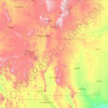
Name: New Mexico topographic map, elevation, terrain.
Location: New Mexico, United States (31.33221 -109.05022 37.00018 -103.00223)
Average elevation: 1,687 m
Minimum elevation: 744 m
Maximum elevation: 3,830 m
Over four–fifths of New Mexico is higher than 4,000 feet (1,250 meters) above sea level. The average elevation ranges from up to 8,000 feet (2,500 meters) above sea level in the northwest, to less than 4,000 feet in the southeast. The highest point is Wheeler Peak at over 13,160 feet (4,011 meters) in the Sangre de Cristo Mountains, while the lowest is the Red Bluff Reservoir at around 2,840 feet (866 meters), in the southeastern corner of the state.
Other topographic maps
Click on a map to view its topography, its elevation and its terrain.
Brooklyn
United States > New York > New York
Brooklyn, Kings County, New York, United States
Average elevation: 9 m
Sarasota
United States > Florida > Sarasota County
Sarasota, Sarasota County, Florida, United States
Average elevation: 7 m
Jacksonville
United States > Florida > Duval County
Jacksonville, Duval County, Florida, United States
Average elevation: 10 m
Madison
United States > Wisconsin > Dane County
Madison, Dane County, Wisconsin, United States
Average elevation: 284 m
Spokane
United States > Washington > Spokane County
Spokane, Spokane County, Washington, United States
Average elevation: 655 m
Appalachian Mountains
United States > North Carolina > Yancey County
Appalachian Mountains, Yancey County, North Carolina, United States
Average elevation: 1,463 m
Allegheny County
Allegheny County, Pennsylvania, United States
Average elevation: 325 m
Albuquerque
United States > New Mexico > Bernalillo County
Albuquerque, Bernalillo County, New Mexico, United States
Average elevation: 1,688 m
Central Park
United States > New York > New York County > New York
Central Park, New York County, New York, United States
Average elevation: 26 m
Palm Beach County
Palm Beach County, Florida, United States
Average elevation: 5 m
Lancaster County
Lancaster County, Pennsylvania, United States
Average elevation: 158 m
Staten Island
United States > New York > New York
Staten Island, Richmond County, New York, United States
Average elevation: 9 m
Taos
United States > New Mexico > Taos County
Taos, Taos County, New Mexico, United States
Average elevation: 2,180 m
Sacramento
United States > California > Sacramento County
Sacramento, Sacramento County, California, United States
Average elevation: 10 m
Fort Worth
United States > Texas > Tarrant County
Fort Worth, Tarrant County, Texas, United States
Average elevation: 212 m
Hudson River
Hudson River, New Jersey, 12834:12871, United States
Average elevation: 297 m
New Orleans
United States > Louisiana > Orleans Parish
New Orleans, Orleans Parish, Louisiana, United States
Average elevation: 1 m