
Tijuana topographic map
Interactive map
Click on the map to display elevation.
About this map
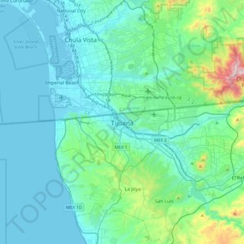
Name: Tijuana topographic map, elevation, terrain.
Average elevation: 141 m
Minimum elevation: -2 m
Maximum elevation: 1,074 m
Housing development in the Tijuana Hills has led to eradication of many seasonal mountain streams. This lack of natural drainage makes places within the city vulnerable to landslides during the rainy season. The varied terrain of Tijuana gives the city elevation extremes that range from sea level to 790 meters (2,590 ft). As downtown Tijuana was built at the bottom of the river valley, the district is subject to seasonal flooding created by drain-off from the Tijuana Hills. During this time, east-bound portions of the Via Rapida (east–west highway) may be blocked off by the Tijuana Police due to hazardous conditions.