
Munich topographic map
Interactive map
Click on the map to display elevation.
About this map
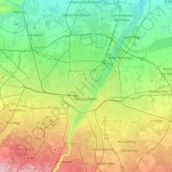
Name: Munich topographic map, elevation, terrain.
Location: Munich, Bavaria, Germany (48.06162 11.36078 48.24812 11.72291)
Average elevation: 524 m
Minimum elevation: 466 m
Maximum elevation: 633 m
Munich lies on the elevated plains of Upper Bavaria, about 50 km (31 mi) north of the northern edge of the Alps, at an altitude of about 520 m (1,706 ft) ASL. The local rivers are the Isar and the Würm. Munich is situated in the Northern Alpine Foreland. The northern part of this sandy plateau includes a highly fertile flint area which is no longer affected by the folding processes found in the Alps, while the southern part is covered with morainic hills. Between these are fields of fluvio-glacial out-wash, such as around Munich. Wherever these deposits get thinner, the ground water can permeate the gravel surface and flood the area, leading to marshes as in the north of Munich.
Other topographic maps
Click on a map to view its topography, its elevation and its terrain.
Frixing
Germany > Bavaria > Landkreis Mühldorf am Inn > Erharting
Frixing, Erharting, Rohrbach (VGem), Landkreis Mühldorf am Inn, Bavaria, 84453, Germany
Average elevation: 412 m
Eyerlohe
Germany > Bavaria > Ansbach (district)
Eyerlohe, Aurach, Ansbach (district), Bavaria, 91589, Germany
Average elevation: 432 m
Wind
Germany > Bavaria > Landkreis Bamberg
Wind, Pommersfelden, Landkreis Bamberg, Bavaria, 96178, Germany
Average elevation: 284 m
Großer Arber
Germany > Bavaria > Landkreis Regen > Bayerisch Eisenstein
Großer Arber, Bayerisch Eisenstein, Landkreis Regen, Bavaria, Germany
Average elevation: 1,141 m
Oberreichenbach
Germany > Bavaria > Landkreis Erlangen-Höchstadt
Oberreichenbach, Aurachtal (VGem), Landkreis Erlangen-Höchstadt, Bavaria, 91097, Germany
Average elevation: 352 m
Gersthofen
Germany > Bavaria > Augsburg (district)
Gersthofen, Augsburg (district), Bavaria, 86368, Germany
Average elevation: 466 m
Oberammergau
Germany > Bavaria > Landkreis Garmisch-Partenkirchen
Oberammergau, Landkreis Garmisch-Partenkirchen, Bavaria, 82487, Germany
Average elevation: 1,064 m
85413
Germany > Bavaria > Landkreis Freising > Margarethenried > Sixt in der Point
85413, Sixt in der Point, Margarethenried, Hörgertshausen, Mauern (VGem), Landkreis Freising, Bavaria, Germany
Average elevation: 484 m
Beuerberg
Germany > Bavaria > Landkreis Bad Tölz-Wolfratshausen
Beuerberg, Eurasburg, Landkreis Bad Tölz-Wolfratshausen, Bavaria, 82547, Germany
Average elevation: 618 m
Kapitelshöfe
Kapitelshöfe, Würzburg Altstadt, Würzburg, Bavaria, 97070, Germany
Average elevation: 224 m
Ries
Germany > Bavaria > Landkreis Donau-Ries
Ries, Landkreis Donau-Ries, Bavaria, Germany
Average elevation: 484 m
Eurasburg
Germany > Bavaria > Landkreis Aichach-Friedberg
Eurasburg, Dasing, Landkreis Aichach-Friedberg, Bavaria, 86495, Germany
Average elevation: 514 m
Burgau
Germany > Bavaria > Landkreis Günzburg
Burgau, Landkreis Günzburg, Bavaria, 89331, Germany
Average elevation: 474 m
Langenberg
Germany > Bavaria > Landkreis Kitzingen
Langenberg, Geiselwind, Landkreis Kitzingen, Bavaria, 96160, Germany
Average elevation: 399 m
Schwöb
Germany > Bavaria > Landkreis Berchtesgadener Land
Schwöb, Schönau am Königssee, Landkreis Berchtesgadener Land, Bavaria, 83471, Germany
Average elevation: 770 m
Schönberg
Germany > Bavaria > Landkreis Traunstein > Kienberg
Schönberg, Kienberg, Obing (VGem), Landkreis Traunstein, Bavaria, 83361, Germany
Average elevation: 538 m
Trainmeusel
Germany > Bavaria > Landkreis Forchheim > Wiesenttal
Trainmeusel, Wiesenttal, Landkreis Forchheim, Bavaria, 91346, Germany
Average elevation: 433 m
Eglfing
Germany > Bavaria > Landkreis München > Haar
Eglfing, Haar, Landkreis München, Bavaria, 85540, Germany
Average elevation: 540 m
Schmelzmühle
Germany > Bavaria > Landkreis Amberg-Sulzbach > Freihung
Schmelzmühle, Freihung, Landkreis Amberg-Sulzbach, Bavaria, 92271, Germany
Average elevation: 427 m
Hohenfels
Germany > Bavaria > Landkreis Neumarkt in der Oberpfalz
Hohenfels, Landkreis Neumarkt in der Oberpfalz, Bavaria, 92366, Germany
Average elevation: 467 m
Olching
Germany > Bavaria > Landkreis Fürstenfeldbruck
Olching, Landkreis Fürstenfeldbruck, Bavaria, 82140, Germany
Average elevation: 509 m
Eichstätt
Germany > Bavaria > Landkreis Eichstätt
Eichstätt, Landkreis Eichstätt, Bavaria, 85072, Germany
Average elevation: 490 m
82140
Germany > Bavaria > Landkreis Fürstenfeldbruck > Olching
82140, Olching, Landkreis Fürstenfeldbruck, Bavaria, Germany
Average elevation: 504 m
Brunnen
Germany > Bavaria > Landkreis Neuburg-Schrobenhausen
Brunnen, Schrobenhausen, Landkreis Neuburg-Schrobenhausen, Bavaria, 86564, Germany
Average elevation: 399 m
Kolbermoor
Germany > Bavaria > Landkreis Rosenheim
Kolbermoor, Landkreis Rosenheim, Bavaria, 83059, Germany
Average elevation: 467 m
Oberdaching
Germany > Bavaria > Landkreis Dingolfing-Landau > Pilsting
Oberdaching, Pilsting, Landkreis Dingolfing-Landau, Bavaria, Germany
Average elevation: 399 m
Tauting
Germany > Bavaria > Landkreis Weilheim-Schongau
Tauting, Eglfing, Huglfing (VGem), Landkreis Weilheim-Schongau, Bavaria, Germany
Average elevation: 650 m
Deggendorf
Germany > Bavaria > Landkreis Deggendorf
Deggendorf, Landkreis Deggendorf, Bavaria, 94469, Germany
Average elevation: 449 m
Mitteleschenbach
Germany > Bavaria > Ansbach (district)
Mitteleschenbach, Wolframs-Eschenbach (VGem), Ansbach (district), Bavaria, 91734, Germany
Average elevation: 439 m
Gattendorf
Germany > Bavaria > Landkreis Hof
Gattendorf, Verwaltungsgemeinschaft Feilitzsch, Landkreis Hof, Bavaria, 95185, Germany
Average elevation: 547 m
Tutzing
Germany > Bavaria > Landkreis Starnberg
Tutzing, Landkreis Starnberg, Bavaria, 82327, Germany
Average elevation: 632 m
Bierhütte
Germany > Bavaria > Landkreis Freyung-Grafenau
Bierhütte, Hohenau, Landkreis Freyung-Grafenau, Bavaria, 94545, Germany
Average elevation: 716 m
Kulmbach
Germany > Bavaria > Landkreis Kulmbach
Kulmbach, Landkreis Kulmbach, Bavaria, 95326, Germany
Average elevation: 395 m
Selb
Germany > Bavaria > Landkreis Wunsiedel im Fichtelgebirge
Selb, Landkreis Wunsiedel im Fichtelgebirge, Bavaria, 95100, Germany
Average elevation: 589 m
Walking
Germany > Bavaria > Landkreis Rottal-Inn > Wittibreut
Walking, Wittibreut, Landkreis Rottal-Inn, Bavaria, 84384, Germany
Average elevation: 504 m
Hobbach
Germany > Bavaria > Landkreis Miltenberg > Eschau
Hobbach, Eschau, Landkreis Miltenberg, Bavaria, Germany
Average elevation: 303 m
Rain
Germany > Bavaria > Landkreis Rosenheim > Kiefersfelden
Rain, Kiefersfelden, Landkreis Rosenheim, Bavaria, 83088, Germany
Average elevation: 538 m
Ramsau
Germany > Bavaria > Landkreis Rosenheim > Nußdorf am Inn
Ramsau, Nußdorf am Inn, Landkreis Rosenheim, Bavaria, 83131, Germany
Average elevation: 602 m
Pfarrkirchen
Germany > Bavaria > Landkreis Rottal-Inn
Pfarrkirchen, Landkreis Rottal-Inn, Bavaria, 84347, Germany
Average elevation: 429 m
Muth
Germany > Bavaria > Landkreis Passau > Loizersdorf
Muth, Loizersdorf, Tittling, Tittling (VGem), Landkreis Passau, Bavaria, 94104, Germany
Average elevation: 474 m
Neuhausen
Germany > Bavaria > Landkreis Deggendorf
Neuhausen, Offenberg, Landkreis Deggendorf, Bavaria, 94560, Germany
Average elevation: 341 m
Marktheidenfeld
Germany > Bavaria > Landkreis Main-Spessart
Marktheidenfeld, Landkreis Main-Spessart, Bavaria, 97828, Germany
Average elevation: 260 m
Bergstein
Germany > Bavaria > Landkreis Amberg-Sulzbach > Illschwang
Bergstein, Illschwang, Illschwang (VGem), Landkreis Amberg-Sulzbach, Bavaria, 92278, Germany
Average elevation: 548 m
Obersalzberg
Germany > Bavaria > Landkreis Berchtesgadener Land > Berchtesgaden > Untersalzberg I
Obersalzberg, Untersalzberg I, Berchtesgaden, Landkreis Berchtesgadener Land, Bavaria, 83471, Germany
Average elevation: 933 m
Pittenhart
Germany > Bavaria > Landkreis Traunstein
Pittenhart, Obing (VGem), Landkreis Traunstein, Bavaria, 83132, Germany
Average elevation: 567 m
Weitnau
Germany > Bavaria > Landkreis Oberallgäu
Weitnau, Weitnau (VGem), Landkreis Oberallgäu, Bavaria, 87480, Germany
Average elevation: 887 m
Putting
Germany > Bavaria > Landkreis Rottal-Inn > Wurmannsquick
Putting, Wurmannsquick, Landkreis Rottal-Inn, Bavaria, 84329, Germany
Average elevation: 464 m