
Andalusia topographic map
Interactive map
Click on the map to display elevation.
About this map
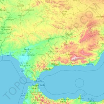
Name: Andalusia topographic map, elevation, terrain.
Location: Andalusia, Spain (35.93764 -7.52269 38.72909 -1.62980)
Average elevation: 378 m
Minimum elevation: -2 m
Maximum elevation: 3,273 m
Andalusia sits at a latitude between 36° and 38° 44' N, in the warm-temperate region. In general, it experiences a hot-summer Mediterranean climate, with dry summers influenced by the Azores High, but subject to occasional torrential rains and extremely hot temperatures. In the winter, the tropical anticyclones move south, allowing cold polar fronts to penetrate the region. Still, within Andalusia there is considerable climatic variety. From the extensive coastal plains one may pass to the valley of the Guadalquivir, barely above sea level, then to the highest altitudes in the Iberian peninsula in the peaks of the Sierra Nevada. In a mere 50 km (31 mi) one can pass from the subtropical coast of the province of Granada to the snowy peaks of Mulhacén. Andalusia also includes both the dry Tabernas Desert in the province of Almería and the Sierra de Grazalema Natural Park in the province of Cádiz, which experiences Spain's greatest rainfall.
Other topographic maps
Click on a map to view its topography, its elevation and its terrain.
La Atalaya
Spain > Santa María de Guía de Gran Canaria
La Atalaya, Santa María de Guía de Gran Canaria, Las Palmas, Canary Islands, 35450, Spain
Average elevation: 132 m
Mutxamel
Mutxamel, l'Alacantí, Alacant / Alicante, Valencian Community, Spain
Average elevation: 103 m
Foronda
Spain > Autonomous Community of the Basque Country > Gasteizko kuadrilla/Cuadrilla de Vitoria > Vitoria-Gasteiz
Foronda, Vitoria-Gasteiz, Gasteizko kuadrilla/Cuadrilla de Vitoria, Álava, Autonomous Community of the Basque Country, 01196, Spain
Average elevation: 525 m
Madrid
Spain > Community of Madrid > Área metropolitana de Madrid y Corredor del Henares
Madrid, Área metropolitana de Madrid y Corredor del Henares, Community of Madrid, Spain
Average elevation: 671 m
Aneto
Spain > Aragon > La Ribagorza > Benasque/Benás
Aneto, Benasque/Benás, La Ribagorza, Huesca, Aragon, Spain
Average elevation: 2,925 m
Serra de Tramuntana
Spain > Balearic Islands > Serra de Tramuntana
Serra de Tramuntana, Balearic Islands, Spain
Average elevation: 175 m
Nande
Spain > Galicia > Bergantiños
Nande, Laxe, Bergantiños, A Coruña, Galicia, Spain
Average elevation: 172 m
Puente de Domingo Flórez
Spain > Castile and León > El Bierzo > Puente de Domingo Flórez
Puente de Domingo Flórez, El Bierzo, León, Castile and León, 24380, Spain
Average elevation: 527 m
A Cova
Spain > Galicia > Terra de Lemos > O Saviñao
A Cova, O Saviñao, Terra de Lemos, Lugo, Galicia, Spain
Average elevation: 458 m
Zapurza
Spain > Iruñerria / Comarca de Pamplona > Ezcabarte > Orrio
Zapurza, Orrio, Ezcabarte, Iruñerria / Comarca de Pamplona, 31193, Spain
Average elevation: 598 m
Lumbier
Spain > Zangozerria / Comarca de Sangüesa
Lumbier, Zangozerria / Comarca de Sangüesa, 31440, Spain
Average elevation: 591 m
Fet
Spain > Aragon > La Ribagorza > Viacamp y Litera/Viacamp i Lliterà
Fet, Viacamp y Litera/Viacamp i Lliterà, La Ribagorza, Huesca, Aragon, Spain
Average elevation: 686 m
Mara
Spain > Aragon > Comunidad de Calatayud
Mara, Comunidad de Calatayud, Zaragoza, Aragon, Spain
Average elevation: 773 m
La Jalva
Spain > Castile and León > Encinas de Abajo
La Jalva, Encinas de Abajo, Salamanca, Castile and León, 37874, Spain
Average elevation: 818 m
Mirador de Cosentino
Spain > Andalusia > Valle del Almanzora > Macael
Mirador de Cosentino, AL-840, Macael, Valle del Almanzora, Almeria, Andalusia, 04867, Spain
Average elevation: 813 m
La Andada
Spain > Castile-La Mancha > Horcajo de Santiago
La Andada, Horcajo de Santiago, Cuenca, Castile-La Mancha, Spain
Average elevation: 761 m
Villarreal
Spain > Valencian Community > Castelló / Castellón
Villarreal, la Plana Baixa, Castelló / Castellón, Valencian Community, 12540, Spain
Average elevation: 42 m
Torrevieja
Spain > Valencian Community > el Baix Segura / La Vega Baja del Segura
Torrevieja, el Baix Segura / La Vega Baja del Segura, Alacant / Alicante, Valencian Community, Spain
Average elevation: 7 m
Las Médulas
Spain > Castile and León > El Bierzo > Borrenes
Las Médulas, Borrenes, El Bierzo, León, Castile and León, 24444, Spain
Average elevation: 631 m
Barallobre
Spain > Galicia > Ferrol > Fene
Barallobre, Fene, Ferrol, A Coruña, Galicia, 15528, Spain
Average elevation: 50 m
Sant Antoni
Spain > Catalonia > Lower Empordà
Sant Antoni, Calonge i Sant Antoni, Lower Empordà, Girona, Catalonia, 17251, Spain
Average elevation: 13 m
El Raso
Spain > Castile and León > Arenas de San Pedro
El Raso, Arenas de San Pedro, Ávila, Castile and León, 05417, Spain
Average elevation: 1,770 m
Móra la Nova
Spain > Catalonia > Ribera d'Ebre
Móra la Nova, Ribera d'Ebre, Tarragona, Catalonia, 43770, Spain
Average elevation: 69 m
Carrer dels Ullals
Spain > Valencian Community > Guardamar de la Safor
Carrer dels Ullals, Platja de Guardamar de la Safor, Guardamar de la Safor, la Safor, Valencia, Valencian Community, 46710, Spain
Average elevation: 9 m
Castillo de Peñiscola
Spain > Valencian Community > Castelló / Castellón > Peníscola / Peñíscola
Castillo de Peñiscola, Plaza Armas, Peníscola / Peñíscola, el Baix Maestrat, Castelló / Castellón, Valencian Community, 12528, Spain
Average elevation: 5 m
Cabrera
Spain > Balearic Islands > Palma
Cabrera, Palma, Balearic Islands, Spain
Average elevation: 25 m
Horta de Sant Joan
Spain > Catalonia > Terra Alta
Horta de Sant Joan, Terra Alta, Tarragona, Catalonia, 43596, Spain
Average elevation: 526 m
Los Dragos
Los Dragos, Moya, Las Palmas, Canary Islands, 35432, Spain
Average elevation: 231 m
Zierbena
Spain > Autonomous Community of the Basque Country
Zierbena, Biscay, Autonomous Community of the Basque Country, 48508, Spain
Average elevation: 53 m
Rao
Spain > Galicia > Os Ancares > Navia de Suarna
Rao, Navia de Suarna, Os Ancares, Lugo, Galicia, 27652, Spain
Average elevation: 970 m
Luna
Spain > Aragon > Cinco Villas
Luna, Cinco Villas, Zaragoza, Aragon, 50610, Spain
Average elevation: 498 m
Montecillo
Spain > Community of Madrid > Villaconejos
Montecillo, Villaconejos, Community of Madrid, 28360, Spain
Average elevation: 677 m