
County Wicklow topographic map
Interactive map
Click on the map to display elevation.
About this map
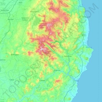
Name: County Wicklow topographic map, elevation, terrain.
Location: County Wicklow, Leinster, Ireland (52.68198 -6.79229 53.23431 -5.99758)
Average elevation: 166 m
Minimum elevation: 0 m
Maximum elevation: 927 m
The county experiences a narrow annual temperature range. Typical daytime highs range from 17–22 °C (63–72 °F) throughout the county in July and August, with overnight lows in the 11–14 °C (52–57 °F) range, although temperatures in the mountains can be 5–10 °C (41–50 °F) lower. Mean January temperatures range from 7 °C (45 °F) on the coast to 0 °C (32 °F) at high elevations. Precipitation is fairly evenly distributed throughout the year, although the wettest months (October and November) receive roughly twice as much rain as the driest months (February, March and April). The driest area of Wicklow is the northeast corner of the county, which is protected from the prevailing south-westerly winds by the Wicklow Mountains and receives around 750 mm (30 in) of rainfall per year. The coastal region of County Dublin immediately to the north is the driest location in all of Ireland as a result of the rain shadow created by the mountains.
Other topographic maps
Click on a map to view its topography, its elevation and its terrain.
Mother Mountain
Mother Mountain, The Municipal District of Nenagh, County Tipperary, Munster, Ireland
Average elevation: 368 m
Lower Lough Bray
Lower Lough Bray, Powerscourt ED, The Municipal District of Bray, County Wicklow, Leinster, Ireland
Average elevation: 455 m
Rossaveel
Rossaveel, Conamara Municipal District, County Galway, Connacht, H91 A2T6, Ireland
Average elevation: 14 m
Mahony’s Point
Mahony’s Point, Killarney Rural ED, Killarney Municipal District, County Kerry, Munster, V93 PR62, Ireland
Average elevation: 24 m
Conamara Municipal District
Conamara Municipal District, County Galway, Connacht, Ireland
Average elevation: 51 m
Mayo Abbey
Mayo Abbey, Castlebar Municipal District, County Mayo, Connacht, F12 E7W7, Ireland
Average elevation: 50 m
Waterford
Waterford, County Waterford, Munster, Ireland
Average elevation: 33 m
Cliffs of Moher
Cliffs of Moher, Ballysteen ED, West Clare Municipal District, County Clare, Munster, Ireland
Average elevation: 55 m
Portumna
Portumna, Loughrea Municipal District, County Galway, Connacht, Ireland
Average elevation: 40 m
Buffy Lough
Buffy Lough, Oughterard ED, Conamara Municipal District, County Galway, Connacht, Ireland
Average elevation: 84 m
Rockfort
Rockfort, Brinny ED, The Municipal District of Bandon-Kinsale, County Cork, Munster, Ireland
Average elevation: 53 m
Ross Castle
Ross Castle, Ross Road, Killarney Rural ED, Killarney Municipal District, County Kerry, Munster, V93 KR0H, Ireland
Average elevation: 19 m
Ballyshoneen
Ireland > County Cork > Municipal District of Macroom
Ballyshoneen, Dripsey, Municipal District of Macroom, County Cork, Munster, Ireland
Average elevation: 120 m
Castlemartyr
Castlemartyr, Castlemartyr ED, The Municipal District of East Cork, County Cork, Munster, Ireland
Average elevation: 16 m
Attanagh
Attanagh, The Municipal District of Castlecomer, County Kilkenny, Leinster, Ireland
Average elevation: 154 m
Fermoyle
Fermoyle, Banteer ED, The Municipal District of Kanturk – Mallow, County Cork, Munster, Ireland
Average elevation: 193 m
Ardfield
Ardfield, Ardfield ED, West Cork, County Cork, Munster, P85 HC03, Ireland
Average elevation: 62 m
The Municipal District of Wicklow
The Municipal District of Wicklow, County Wicklow, Leinster, Ireland
Average elevation: 263 m
The Municipal District of Dungarvan — Lismore
The Municipal District of Dungarvan — Lismore, County Waterford, Munster, Ireland
Average elevation: 120 m
Limerick
Ireland > County Limerick > Limerick
Limerick, The Metropolitan District of Limerick City, County Limerick, Munster, Ireland
Average elevation: 10 m
Wexford
Ireland > County Wexford > Wexford
Wexford, The Borough District of Wexford, County Wexford, Leinster, Ireland
Average elevation: 23 m
Morning Star
Ireland > County Limerick > The Municipal District of Cappamore — Kilmallock
Morning Star, Athlacca ED, The Municipal District of Cappamore — Kilmallock, County Limerick, Munster, Ireland
Average elevation: 46 m
Liscannor
Liscannor, Liscannor ED, West Clare Municipal District, County Clare, Munster, Ireland
Average elevation: 13 m
Rathfarnham Village ED
Rathfarnham Village ED, Rathfarnham, South Dublin, County Dublin, Leinster, D6W, Ireland
Average elevation: 56 m
South and West Kerry Municipal District (2014-2019)
South and West Kerry Municipal District (2014-2019), Dingle, Kenmare Municipal District, County Kerry, Munster, Ireland
Average elevation: 121 m
Dún Laoghaire
Dún Laoghaire, Dún Laoghaire-Rathdown, County Dublin, Leinster, A96 A258, Ireland
Average elevation: 21 m
Galway City
Galway, Galway City, County Galway, Connacht, H91 YD86, Ireland
Average elevation: 26 m
Townparks
Ireland > Galway City > Galway City
Townparks, St Nicholas, Galway City, County Galway, Connacht, Ireland
Average elevation: 7 m
Lislorkan North
Lislorkan North, Ballysteen, West Clare Municipal District, County Clare, Munster, Ireland
Average elevation: 93 m
Churchtown-Orwell ED
Churchtown-Orwell ED, Dublin 14, Dún Laoghaire-Rathdown, County Dublin, Leinster, Ireland
Average elevation: 54 m