
Make a donation
North Carolina topographic map
Click on the map to display elevation.
Make a donation
North Carolina
North Carolina features a diverse topography that can be divided into three distinct regions: the Coastal Plain, the Piedmont, and the Appalachian Mountains. The Coastal Plain, which occupies the eastern part of the state, is characterized by flat and gently sloping land, with elevations typically less than 300 feet (91 meters). This area includes vast wetlands and estuaries, along with barrier islands like the Outer Banks, known for their sandy beaches and unique ecosystems. Moving westward, the Piedmont region presents a more undulating landscape, with rolling hills and elevations ranging from 300 to about 1,500 feet (91 to 457 meters). This region is the state's urban and industrial center, home to major cities and fertile agricultural land. Finally, the Appalachian Mountains dominate the western part of the state, where peaks rise dramatically, with Mount Mitchell reaching over 6,600 feet (2,012 meters), making it the highest point in eastern North America. This mountainous terrain features deep valleys and lush forests, contributing to the region's rich biodiversity and scenic beauty.
Make a donation
About this map
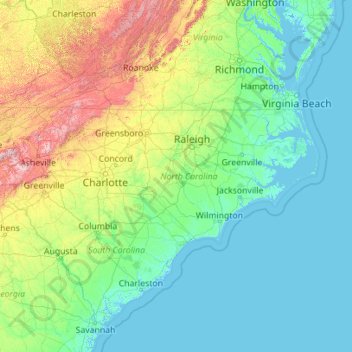
Name: North Carolina topographic map, elevation, terrain.
Location: North Carolina, United States (33.75288 -84.32183 36.58816 -75.40012)
Average elevation: 163 m
Minimum elevation: -3 m
Maximum elevation: 1,945 m
Make a donation
Other topographic maps
Click on a map to view its topography, its elevation and its terrain.
San Francisco Bay Area
United States > California > San Francisco
The San Francisco Bay Area is characterized by a diverse and dynamic topography shaped by geological processes over millions of years. This region features a combination of coastal plains, steep hills, and rugged mountains, all influenced by the tectonic activity associated with the nearby San Andreas Fault…
Average elevation: 113 m
Appalachian Mountains
United States > North Carolina > Yancey County
The Appalachian Mountains (French: Appalaches), often called the Appalachians, are a system of mountains in eastern to northeastern North America. The Appalachians first formed roughly 480 million years ago during the Ordovician Period. They once reached elevations similar to those of the Alps and the Rocky…
Average elevation: 1,463 m
Make a donation
Appalachian Mountains
United States > North Carolina > Yancey County
The Appalachian Mountains (French: Appalaches), often called the Appalachians, are a system of mountains in eastern to northeastern North America. The Appalachians first formed roughly 480 million years ago during the Ordovician Period. They once reached elevations similar to those of the Alps and the Rocky…
Average elevation: 1,463 m
Baltimore
United States > Maryland > Baltimore
Baltimore is in north-central Maryland on the Patapsco River close to where it empties into the Chesapeake Bay. The city is also located on the fall line between the Piedmont Plateau and the Atlantic coastal plain, which divides Baltimore into "lower city" and "upper city". The city's elevation ranges from sea…
Average elevation: 65 m
Anna Maria island
United States > Florida > Manatee County
Anna Maria Island features a flat, sandy topography typical of a barrier island on the Gulf Coast. With an average elevation of around 15 feet above sea level, the terrain includes broad beaches, low dunes, and narrow stretches of sandy soil, making it highly vulnerable to storm surges and tidal flooding. The…
Average elevation: 2 m
Columbus
United States > Ohio > Franklin County > Columbus
The confluence of the Scioto and Olentangy rivers is just north-west of Downtown Columbus. Several smaller tributaries course through the Columbus metropolitan area, including Alum Creek, Big Walnut Creek, and Darby Creek. Columbus is considered to have relatively flat topography thanks to a large glacier that…
Average elevation: 255 m
Make a donation
Port Charlotte
United States > Florida > Charlotte County
Port Charlotte is characterized by a predominantly flat and low-lying terrain, typical of Florida’s coastal landscape. The area features a network of waterways, including the Peace River and Charlotte Harbor, which provide ample opportunities for recreational activities like boating and fishing. Elevations…
Average elevation: 4 m
Parrish
United States > Florida > Manatee County
Parrish features a predominantly flat terrain with an average elevation of approximately 36 feet above sea level. The area's landscape is characterized by gently rolling hills and low-lying regions, making it typical of the Central Florida topography. Surrounding Parrish are numerous wetlands and drainage…
Average elevation: 12 m
Make a donation
Nokomis
United States > Florida > Sarasota County
Nokomis features a predominantly flat and low-lying terrain characteristic of the coastal region. The elevation in Nokomis rarely exceeds 15 feet above sea level, contributing to its vulnerability to tidal influences and storm surges. The area is interspersed with wetlands and mangroves, particularly near the…
Average elevation: 5 m
Make a donation
Albuquerque
United States > New Mexico > Bernalillo County
Albuquerque is located in north-central New Mexico. To its east are the Sandia–Manzano Mountains. The Rio Grande flows north to south through its center, while the West Mesa and Petroglyph National Monument make up the western part of the city. Albuquerque has one of the highest elevations of any major city…
Average elevation: 1,671 m
Make a donation
Lemhi Pass
United States > Idaho > Lemhi County
Lemhi Pass is a high mountain pass in the Beaverhead Mountains, part of the Bitterroot Range in the Rocky Mountains and within Salmon-Challis National Forest. The pass lies on the Montana-Idaho border on the Continental Divide, at an elevation of 7,373 feet (2,247 m) above sea level. It is accessed via Lemhi…
Average elevation: 2,218 m
Florida Keys
United States > Florida > Monroe County
Tropical cyclones present special dangers and challenges to the entire Keys. Because no area of the islands is more than 20 feet (6.1 m) above sea level (and many are only a few feet elevation), and water surrounds the islands, nearly every neighborhood is subject to flooding as well as hurricane winds. In…
Average elevation: 0 m
Uinta Mountains
The high Uintas were extensively glaciated during the last ice age, and most of the large stream valleys on both the north and south sides of the range held long valley glaciers. However, despite reaching to over 13,500 feet (4,110 m) in elevation, the climate today is sufficiently dry that no glaciers…
Average elevation: 2,363 m
Make a donation
Bagby Hot Springs
United States > Oregon > Clackamas County
Bagby Hot Springs are natural hot springs in the Mount Hood National Forest, about 67 miles (108 km) southeast of Portland, Oregon, United States and about 98 miles (158 km) east of Salem, Oregon. The springs are in the Cascade Mountains in a heavily forested area at elevation 2280 ft (695 m). They are just…
Average elevation: 880 m
Johnston Island
The climate is tropical but generally dry. Northeast trade winds are consistent and there is little seasonal temperature variation. With elevation ranging from sea level to 5 m (16 ft) at Summit Peak, the islands contain some low-growing vegetation and palm trees on mostly flat terrain, and no natural fresh…
Average elevation: 1 m
East Texas
United States > Pennsylvania > Lehigh County > Lower Macungie Township
Average elevation: 126 m
Make a donation
Palmyra Atoll
In 1962, the Department of Defense used Palmyra as an observation site during several high-altitude nuclear weapons tests high above Johnston Atoll. A group of about ten men supported the observation posts during this series of tests, while about 40 people carried out the observations.
Average elevation: 0 m
Denali
United States > Alaska > Denali Borough
Denali (/dəˈnɑːli/ də-NAH-lee), federally designated as Mount McKinley, is the highest mountain peak in North America, with a summit elevation of 20,310 feet (6,190 m) above sea level. It is the tallest mountain in the world from base to peak on land, measuring 18,000 ft (5,500 m). With a topographic…
Average elevation: 5,546 m
Make a donation
Estes Park
United States > Colorado > Larimer County
Estes Park sits at an elevation of 7,522 feet (2,293 m) on the front range of the Rocky Mountains at the eastern entrance of the Rocky Mountain National Park. Its north, south and east extremities border the Roosevelt National Forest. Lumpy Ridge lies immediately north of Estes Park.
Average elevation: 2,543 m
Make a donation
Hawksbill
United States > Virginia > Madison County
Hawksbill Mountain is a mountain with an elevation of 4,050 feet (1,234 m). Marking the border between Madison County and Page County in Virginia, the summit of Hawksbill Mountain is the highest point in Shenandoah National Park as well as the highest point in both Madison and Page Counties.
Average elevation: 993 m
Make a donation
Make a donation
Make a donation
Little Saint James Island
United States > United States Virgin Islands > Saint Thomas - Saint John District
Average elevation: 1 m
Boston
United States > Massachusetts > Suffolk County > Boston
Boston has an area of 89.63 sq mi (232.1 km2)—48.4 sq mi (125.4 km2) (54%) of land and41.2 sq mi (106.7 km2) (46%) of water. The city's official elevation, as measured at Logan International Airport, is 19 ft (5.8 m) above sea level. The highest point in Boston is Bellevue Hill at 330 ft (100 m) above sea…
Average elevation: 26 m
McKinleyville
United States > California > Humboldt County
McKinleyville (formerly Minorsville) is a census-designated place (CDP) in Humboldt County, California McKinleyville is located 5.25 miles (8.4 km) north of Arcata, at an elevation of 141 feet (43 m). The population was 15,177 at the 2010 census, up from 13,599 at the time of the 2000 census.
Average elevation: 49 m
Coachella Valley
United States > California > Riverside County > Palm Desert
The area is surrounded on the southwest by the Santa Rosa Mountains, by the San Jacinto Mountains to the west, the Little San Bernardino Mountains to the east and San Gorgonio Mountain to the north. These mountains peak at around 11,000 feet (3,400 m) and tend to average between 5,000 and 7,000 feet (1,500 and…
Average elevation: 72 m
Make a donation
Eden
United States > Utah > Weber County > Ogden Valley
Eden is a census-designated place in Weber County, Utah, United States. It is home to Powder Mountain ski resort. It lies between the North and Middle Fork of the Ogden River, north of Pineview Reservoir, in the Ogden Valley. The elevation is 4,941 feet (1,506 m). The population was 600 at the 2010 census. It…
Average elevation: 1,562 m
Make a donation
Sawtooth Range
United States > Idaho > Custer County
The Sawtooth Range is a mountain range of the Rocky Mountains in central Idaho, United States, reaching a maximum elevation of 10,751 feet (3,277 m) at the summit of Thompson Peak. It encompasses an area of 678 square miles (1,756 km2) spanning parts of Custer, Boise, Blaine, and Elmore counties, and is…
Average elevation: 2,761 m
Make a donation
Make a donation
Santa Cruz Mountains
United States > California > Santa Clara County
The Santa Cruz Mountains are a region of great biological diversity, encompassing cool, moist coastal ecosystems as well as warm, dry chaparral. Much of the area in the Santa Cruz mountains is considered temperate rainforest. In valleys and moist ocean-facing slopes some of the southernmost coast redwoods…
Average elevation: 230 m
Make a donation
Make a donation
Mauna Kea
United States > Hawaii > Hawaiʻi County
Mauna Kea (/ˌmaʊnə ˈkeɪə/; Hawaiian: [ˈmɐwnə ˈkɛjə]; abbreviation for Mauna a Wākea) is a dormant volcano on the island of Hawaiʻi. Its peak is 4,207.3 m (13,803 ft) above sea level, making it the highest point in the state of Hawaiʻi and second-highest peak of an island on Earth. The peak is…
Average elevation: 3,978 m
Central Park
United States > New York > New York County > New York
In June 1856, Fernando Wood appointed a "consulting board" of seven people, headed by author Washington Irving, to inspire public confidence in the proposed development. Wood hired military engineer Egbert Ludovicus Viele as the park's chief engineer, tasking him with a topographical survey of the site. The…
Average elevation: 26 m
Make a donation
Navarre
United States > Florida > Santa Rosa County
Navarre is located at 30°24′04″N 86°51′47″W / 30.401°N 86.863°W / 30.401; -86.863Coordinates: 30°24′04″N 86°51′47″W / 30.401°N 86.863°W / 30.401; -86.863. It is located within a portion of the Florida Panhandle observing the Central Time Zone. Elevation is at an average of 10 feet (3.0 m).
Average elevation: 4 m
Make a donation
Make a donation
Ponte Vedra Beach
United States > Florida > Saint Johns County > Ponte Vedra Beach
Ponte Vedra Beach is characterized by its gently rolling terrain that is primarily flat and lies only about 15 feet above sea level. The landscape is predominantly shaped by coastal dunes and the proximity to the Atlantic Ocean, resulting in sandy beaches interspersed with vegetation typical of barrier island…
Average elevation: 3 m
Morning Star Acres
United States > North Carolina > Mecklenburg County > Charlotte
Average elevation: 206 m
Make a donation
Make a donation
Make a donation
Make a donation