
Make a donation
Tyrol topographic map
Click on the map to display elevation.
Make a donation
About this map
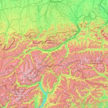
Name: Tyrol topographic map, elevation, terrain.
Location: Tyrol, Austria (46.65137 10.09783 47.74303 12.96600)
Average elevation: 1,410 m
Minimum elevation: 204 m
Maximum elevation: 3,800 m
Make a donation
Other topographic maps
Click on a map to view its topography, its elevation and its terrain.
Make a donation
Make a donation
Großglockner
Austria > Carinthia > Bezirk Spittal an der Drau > Heiligenblut am Großglockner
The Glockner is the highest mountain in the Alps east of the Ortler range, about 175 km (109 mi) away, and, after Mont Blanc, has the second greatest topographic isolation of all mountains in the Alps. Even its topographic prominence, at 2,424 m (7,953 ft), is the second highest after Mont Blanc in the entire…
Average elevation: 3,128 m
Untertauern
Austria > Carinthia > Bezirk Spittal an der Drau > Heiligenblut am Großglockner
Average elevation: 1,682 m
Make a donation
Wechsel
Austria > Lower Austria > Bezirk Neunkirchen > Mönichkirchen > Pfeffergraben
The Wechsel Pass (elevation 980 m, 3,215 ft) is a mountain pass in the Austrian Alps, located between the Bundesländer of Lower Austria and Styria.
Average elevation: 906 m
Make a donation
Make a donation
Make a donation
Hochlantsch
Austria > Styria > Bezirk Bruck-Mürzzuschlag > Breitenau am Hochlantsch
Average elevation: 1,228 m
Make a donation
Make a donation
Make a donation
Make a donation
Vienna
Vienna is located in northeastern Austria, at the easternmost extension of the Alps in the Vienna Basin. The earliest settlement, at the location of today's inner city, was south of the meandering Danube while the city now spans both sides of the river. Elevation ranges from 151 to 542 m (495 to 1,778 ft). The…
Average elevation: 231 m
Make a donation
Hoher Dachstein
Austria > Upper Austria > Bezirk Gmunden > Gosau
The Dachstein massif covers an area of around 600 square kilometres (230 sq mi) with dozens of peaks above 2,500 m, the highest of which are in the southern and southwestern areas. The main summit of the Hoher Dachstein is at an elevation of 2,997 metres (9,833 ft). Seen from the north, the Dachstein massif is…
Average elevation: 2,341 m
Make a donation
Perchtoldsdorfer Heide
Austria > Lower Austria > Bezirk Mödling > Perchtoldsdorf
Average elevation: 312 m
Make a donation
Make a donation
Sankt Marein bei Graz
Austria > Styria > Bezirk Graz-Umgebung > St. Marein bei Graz
Average elevation: 395 m
Großglockner
Austria > Carinthia > Bezirk Spittal an der Drau > Heiligenblut am Großglockner
The Glockner is the highest mountain in the Alps east of the Ortler range, about 175 km (109 mi) away, and, after Mont Blanc, has the second greatest topographic isolation of all mountains in the Alps. Even its topographic prominence, at 2,424 m (7,953 ft), is the second highest after Mont Blanc in the entire…
Average elevation: 3,128 m
Make a donation
Griesleiten
Austria > Lower Austria > Bezirk Waidhofen an der Thaya > Karlstein an der Thaya
Average elevation: 514 m
Make a donation
Make a donation
Maria Ellend
Austria > Lower Austria > Bezirk Bruck an der Leitha > Haslau - Maria Ellend
Average elevation: 173 m
Make a donation
Make a donation
Make a donation
Make a donation
Wartkogel
Austria > Carinthia > Bezirk Wolfsberg > Bad Sankt Leonhard im Lavanttal
Average elevation: 964 m
Freier Seezugang Millstätter See bei Spittal an der Drau, Großegg
Austria > Carinthia > Bezirk Spittal an der Drau > Spittal an der Drau
Average elevation: 677 m
Oberwinklern
Austria > Carinthia > Bezirk Villach-Land > Velden am Wörther See
Average elevation: 753 m
Make a donation
Make a donation
Make a donation
Wöllersdorf
Austria > Lower Austria > Bezirk St. Pölten > Brand-Laaben > Laaben
Average elevation: 518 m
Frießnitz/Breznica
Austria > Carinthia > Bezirk Villach-Land > St. Jakob im Rosental
Average elevation: 559 m
Lamperstätten
Austria > Styria > Bezirk Leibnitz > Sankt Nikolai im Sausal > Mollitsch
Average elevation: 322 m
Make a donation