
Budapest topographic map
Interactive map
Click on the map to display elevation.
About this map
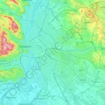
Name: Budapest topographic map, elevation, terrain.
Location: Budapest, Central Hungary, Hungary (47.34969 18.92511 47.61315 19.33493)
Average elevation: 171 m
Minimum elevation: 89 m
Maximum elevation: 557 m
The wide Danube was always fordable at this point because of a small number of islands in the middle of the river. The city has marked topographical contrasts: Buda is built on the higher river terraces and hills of the western side, while the considerably larger Pest spreads out on a flat and featureless sand plain on the river's opposite bank. Pest's terrain rises with a slight eastward gradient, so the easternmost parts of the city lie at the same altitude as Buda's smallest hills, notably Gellért Hill and Castle Hill.
Other topographic maps
Click on a map to view its topography, its elevation and its terrain.
Gellérthegy
Gellérthegy, 11th district, Budapest, Central Hungary, Hungary
Average elevation: 130 m
21st district
21st district, Budapest, Central Hungary, Hungary
Average elevation: 110 m