
Kathmandu topographic map
Interactive map
Click on the map to display elevation.
About this map
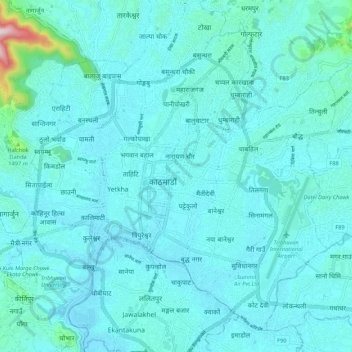
Name: Kathmandu topographic map, elevation, terrain.
Location: Kathmandu, Bagmati Pradesh, Nepal (27.66795 85.26809 27.75132 85.37348)
Average elevation: 1,335 m
Minimum elevation: 1,275 m
Maximum elevation: 2,027 m
Kathmandu is in the northwestern part of the Kathmandu Valley to the north of the Bagmati River and covers an area of 50.7 km2 (19.6 sq mi). The average elevation is 1,400 metres (4,600 ft) above sea level. The city is bounded by several other municipalities of the Kathmandu valley: south of the Bagmati by Lalitpur Metropolitan City (Patan), with which it forms one urban area surrounded by a ring road, to the southwest by Kirtipur and to the east by Madyapur Thimi. To the north the urban area extends into several municipalities; Nagarjun, Tarakeshwor, Tokha, Budhanilkantha, Gokarneshwor and Kageshwori Manohara. However, the urban agglomeration extends well beyond the neighbouring municipalities, e.g. to Bhaktapur, and nearly covers the entire Kathmandu Valley.
Other topographic maps
Click on a map to view its topography, its elevation and its terrain.