
Salt Lake County topographic map
Interactive map
Click on the map to display elevation.
About this map
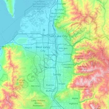
Name: Salt Lake County topographic map, elevation, terrain.
Location: Salt Lake County, Utah, United States (40.41417 -112.26022 40.92185 -111.55319)
Average elevation: 1,811 m
Minimum elevation: 1,278 m
Maximum elevation: 3,493 m
Other topographic maps
Click on a map to view its topography, its elevation and its terrain.
West Jordan
United States > Utah > Salt Lake County
West Jordan, Salt Lake County, Utah, United States
Average elevation: 1,372 m
Torry Pines
United States > Utah > Salt Lake County > Sandy
Torry Pines, Sandy, Salt Lake County, Utah, 84070, United States
Average elevation: 1,373 m
Sandy Heights South
United States > Utah > Salt Lake County > Sandy
Sandy Heights South, Sandy, Salt Lake County, Utah, 84070, United States
Average elevation: 1,371 m
Salt Lake City
United States > Utah > Salt Lake County > Salt Lake City
Salt Lake City, Salt Lake County, Utah, 84139, United States
Average elevation: 1,625 m