
Nowy Targ topographic map
Interactive map
Click on the map to display elevation.
About this map
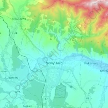
Name: Nowy Targ topographic map, elevation, terrain.
Average elevation: 679 m
Minimum elevation: 567 m
Maximum elevation: 1,135 m
According to the Köppen climate classification, Nowy Targ straddles the border of the Warm Summer Continental (Dfb) and Subarctic (Dfc) climates, with most of the city falling in the Dfb group. The Dfc climate is only found above 800 metres of elevation within Nowy Targ.