
Cofre de Perote topographic map
Interactive map
Click on the map to display elevation.
About this map
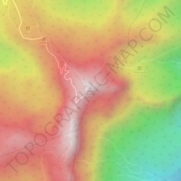
Name: Cofre de Perote topographic map, elevation, terrain.
Location: Cofre de Perote, Perote, Veracruz, Mexico (19.49375 -97.14783 19.49385 -97.14773)
Average elevation: 3,816 m
Minimum elevation: 3,227 m
Maximum elevation: 4,186 m
Other topographic maps
Click on a map to view its topography, its elevation and its terrain.
San Antonio Texas
Mexico > Veracruz > Cosamaloapan de Carpio
San Antonio Texas, Cosamaloapan de Carpio, Veracruz, Mexico
Average elevation: 19 m
El Vizcaíno
Mexico > Veracruz > El Vizcaíno
El Vizcaíno, Coatzintla, Veracruz, Mexico
Average elevation: 123 m
Arroyo Maurita
Arroyo Maurita, Jesús Carranza, Veracruz, 96950, Mexico
Average elevation: 137 m
El Chichón
Mexico > Veracruz > El Chichón
El Chichón, Las Choapas, Veracruz, Mexico
Average elevation: 44 m