
Alta topographic map
Interactive map
Click on the map to display elevation.
About this map
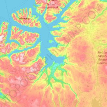
Name: Alta topographic map, elevation, terrain.
Location: Alta, Troms og Finnmark, Norway (69.64545 22.18582 70.44802 24.21823)
Average elevation: 363 m
Minimum elevation: -5 m
Maximum elevation: 1,201 m
Other topographic maps
Click on a map to view its topography, its elevation and its terrain.
Sande
Sande, Holmestrand, Vestfold og Telemark, 3070, Norway
Average elevation: 37 m
Porsgrunn
Porsgrunn, Vestfold og Telemark, Norway
Average elevation: 87 m
Olonkin City
Norway > Jan Mayen > Olonkin City
Olonkin City, Jan Mayen, Norway
Average elevation: 153 m