
MONDOMO topographic map
Interactive map
Click on the map to display elevation.
About this map
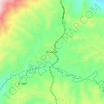
Name: MONDOMO topographic map, elevation, terrain.
Location: MONDOMO, Santander de Quilichao, Norte, Cauca, Colombia (2.87041 -76.57101 2.91041 -76.53101)
Average elevation: 1,397 m
Minimum elevation: 1,193 m
Maximum elevation: 1,727 m
Other topographic maps
Click on a map to view its topography, its elevation and its terrain.
LA AGUSTINA
Colombia > Cauca > Santander de Quilichao
LA AGUSTINA, Santander de Quilichao, Norte, Cauca, RAP Pacífico, Colombia
Average elevation: 1,401 m