
Madavara topographic map
Interactive map
Click on the map to display elevation.
About this map
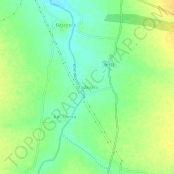
Name: Madavara topographic map, elevation, terrain.
Location: Madavara, Sedam taluku, Kalaburagi District, Karnataka, India (17.10068 77.28676 17.14068 77.32676)
Average elevation: 433 m
Minimum elevation: 419 m
Maximum elevation: 446 m
Other topographic maps
Click on a map to view its topography, its elevation and its terrain.
Kadacharla
India > Karnataka > Sedam taluku > Kadacharla
Kadacharla, Sedam taluku, Kalaburagi district, Karnataka, India
Average elevation: 472 m
Malakheda
India > Karnataka > Sedam taluku > Malakheda
Malakheda, Sedam taluku, Kalaburagi district, Karnataka, 585317, India
Average elevation: 406 m