
Lumbier topographic map
Interactive map
Click on the map to display elevation.
About this map
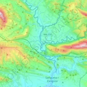
Name: Lumbier topographic map, elevation, terrain.
Location: Lumbier, Zangozerria / Comarca de Sangüesa, 31440, Spain (42.61312 -1.41902 42.68803 -1.17015)
Average elevation: 591 m
Minimum elevation: 393 m
Maximum elevation: 1,341 m
Lumbier is located in the western part of the autonomous region of Navarre at an altitude of 467 metres above sea level. Its municipal area has an area of 57.40 km2 and has borders on the northern side with the municipalities of Urraúl Bajo and Romanzado, on the eastern side with the latter, on the southern side with those of Yesa, Liédena and Sangüesa and on the western side with that of Urraúl Alto.