
Boulogne-Billancourt topographic map
Interactive map
Click on the map to display elevation.
About this map
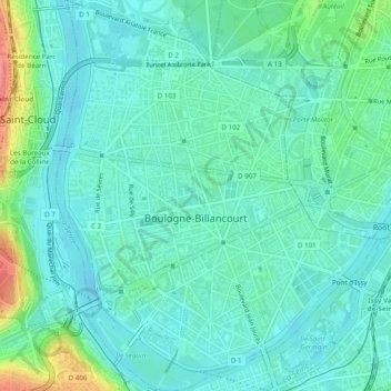
Name: Boulogne-Billancourt topographic map, elevation, terrain.
Average elevation: 43 m
Minimum elevation: 23 m
Maximum elevation: 113 m
Other topographic maps
Click on a map to view its topography, its elevation and its terrain.
Montrouge
France > Ile-de-France > Hauts-de-Seine
Montrouge, Antony, Hauts-de-Seine, Ile-de-France, Metropolitan France, 92120, France
Average elevation: 76 m