
Sinaloa topographic map
Interactive map
Click on the map to display elevation.
About this map
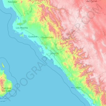
Name: Sinaloa topographic map, elevation, terrain.
Location: Sinaloa, Mexico (22.46713 -109.44463 27.04225 -105.39222)
Average elevation: 749 m
Minimum elevation: -2 m
Maximum elevation: 3,264 m
Sinaloa has a warm climate on the coast; moderately warm climate in the valleys and foothills; moderately cold in the lower mountains, and cold in the higher elevations. Its weather characteristics vary from subtropical, found on coastal plains, to cold in the nearby mountains. Temperatures range from 22 °C (72 °F) to 43 °C (109 °F) with rain and thunderstorms during the rainy season (June to October) and dry conditions throughout most of the year. Its average annual precipitation is 790 millimetres.
Other topographic maps
Click on a map to view its topography, its elevation and its terrain.
Isla de Oraba
Isla de Oraba, Culiacán, Sinaloa, Mexico
Average elevation: 43 m
Villa Bonita
Villa Bonita, Culiacán, Sinaloa, 80199, Mexico
Average elevation: 76 m