
Gandhinagar topographic map
Interactive map
Click on the map to display elevation.
Gandhinagar
Gandhinagar has an average elevation of 81 metres (266 feet). The city sits on the banks of the Sabarmati River, in north-central-east Gujarat. The 20,543 km2 area around Gandhinagar is defined by Gujarat capital territory. It spans an area of 205 km2 (79 sq mi). The river frequently dries up in the summer, leaving only a small stream of water. Gandhinagar is India's tree capital With 54% green cover on its land area.
About this map
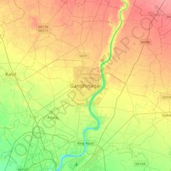
Name: Gandhinagar topographic map, elevation, terrain.
Average elevation: 76 m
Minimum elevation: 40 m
Maximum elevation: 111 m