
Burnaby topographic map
Interactive map
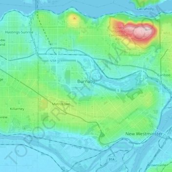
Click on the map to display elevation.
About this map
Name: Burnaby topographic map, elevation, terrain.
Average elevation: 59 m
Minimum elevation: -7 m
Maximum elevation: 373 m
Burnaby occupies 98.6 square kilometres (38.1 sq mi) and is located at the geographic centre of the Metro Vancouver Regional District. The regional district's government is located in Burnaby's Metrotown area. Situated between the city of Vancouver on the west and Port Moody, Coquitlam, and New Westminster on the east, Burnaby is bounded by Burrard Inlet and the Fraser River on the north and south, respectively. Burnaby, Vancouver and New Westminster collectively occupy the major portion of the Burrard Peninsula. The elevation of Burnaby ranges from sea level to a maximum of 370 metres (1,214 ft) atop Burnaby Mountain. Due to its elevation, the city of Burnaby typically has more snowfall during the winter months than nearby Vancouver or Richmond. Overall, the physical landscape of Burnaby is one of hills, ridges, valleys and an alluvial plain.