
Coonoor topographic map
Interactive map
Click on the map to display elevation.
Coonoor
Coonoor is located at 11°20′42″N 76°47′42″E / 11.345°N 76.795°E / 11.345; 76.795. It has an average elevation of 1,650 metres (5413 feet) above sea level. It features a sub-tropical highland climate (Koppen;Cfb) due to high altitude.
About this map
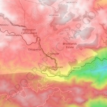
Name: Coonoor topographic map, elevation, terrain.
Location: Coonoor, Nilgiris, Tamil Nadu, 643101, India (11.30594 76.75653 11.38594 76.83653)
Average elevation: 1,764 m
Minimum elevation: 760 m
Maximum elevation: 2,122 m
Other topographic maps
Click on a map to view its topography, its elevation and its terrain.