
Bhor topographic map
Interactive map
Click on the map to display elevation.
About this map
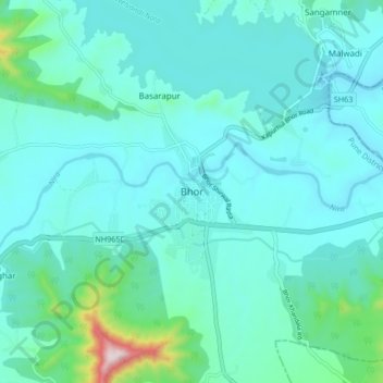
Name: Bhor topographic map, elevation, terrain.
Location: Bhor, Pune District, Maharashtra, 412206, India (18.11081 73.80306 18.19081 73.88306)
Average elevation: 650 m
Minimum elevation: 578 m
Maximum elevation: 1,117 m
Other topographic maps
Click on a map to view its topography, its elevation and its terrain.
Rohida Fort
India > Maharashtra > Bhor > Hathnoshi
Rohida Fort, SH63, Hathnoshi, Bhor, Maharashtra, 412206, India
Average elevation: 806 m
Raireshwar Fort
India > Maharashtra > Bhor
Raireshwar Fort, Kenjalgad trail, Bhor, Pune District, Maharashtra, India
Average elevation: 1,145 m