Geolocate

Raichur topographic map

Click on the map to display elevation.

About this map

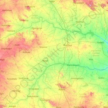
Name: Raichur topographic map, elevation, terrain.

Location: Raichur, Raichur District, Karnataka, India (15.38333 76.46667 16.78333 77.86667)

Average elevation: 401 m

Minimum elevation: 272 m

Maximum elevation: 697 m

Other topographic maps

Click on a map to view its topography, its elevation and its terrain.

Bengaluru

India > Karnataka > Bangalore North

Bengaluru (formerly Bangalore) is situated in the southeastern part of Karnataka, India, within the Bengaluru Urban district. It lies at an elevation of approximately 900 meters (3,000 feet) above sea level, on the Deccan Plateau. This elevated position gives the city a moderate climate, with temperatures…

Average elevation: 886 m

Bengaluru

India > Karnataka > Bangalore North

Bengaluru (formerly Bangalore) is situated in the southeastern part of Karnataka, India, within the Bengaluru Urban district. It lies at an elevation of approximately 900 meters (3,000 feet) above sea level, on the Deccan Plateau. This elevated position gives the city a moderate climate, with temperatures…

Average elevation: 881 m

Bangalore Urban

India > Karnataka

Average elevation: 856 m

HBR Layout

India > Karnataka > Bangalore North > Bengaluru

Average elevation: 893 m

Shirasi Taluk

India > Karnataka

Average elevation: 508 m

Kabini

India > Karnataka

Average elevation: 794 m

Mudalagi taluku

India > Karnataka

Average elevation: 590 m

Chitradurga

India > Karnataka

Average elevation: 635 m

Marathahalli

India > Karnataka > Bangalore East > Bengaluru

Average elevation: 877 m

Kambipura

India > Karnataka > Bangalore South > Kambipura

Average elevation: 771 m

Marathahalli

India > Karnataka > Bangalore East > Bengaluru

Average elevation: 877 m

Bannerughatta

India > Karnataka > Anekal

Average elevation: 894 m

Doddabele

India > Karnataka > Bangalore South > Doddabele

Average elevation: 783 m

Kalkere

India > Karnataka > Anekal > Kalkere

Average elevation: 932 m

Doddabanahalli

India > Karnataka > Bangalore East

Average elevation: 876 m

Maski

India > Karnataka > Maski taluku

Average elevation: 469 m

Avalahalli

India > Karnataka > Bangalore East

Average elevation: 875 m

Coorg

India > Karnataka

Kodagu is located on the eastern slopes of the Western Ghats. It has a geographical area of 4,102 km2 (1,584 sq mi). The district is bordered by Dakshina Kannada district to the northwest, Hassan district to the north, Mysore district to the east, Kasaragod district of Kerala in west and Kannur district of…

Average elevation: 560 m

Varthur

India > Karnataka > Bangalore East > Bengaluru

Average elevation: 874 m

Mudalagi taluku

India > Karnataka

Average elevation: 590 m

Ashwath Nagar

India > Karnataka > Bangalore East > Bengaluru

Average elevation: 883 m

Gunjur

India > Karnataka > Bangalore East > Bengaluru

Average elevation: 885 m

Anchepalya Lake

India > Karnataka > Bangalore North > Bengaluru

Average elevation: 867 m

Suragajakkanahalli

India > Karnataka > Anekal

Average elevation: 924 m

Suragajakkanahalli

India > Karnataka > Anekal

Average elevation: 924 m

Jakkasandra

India > Karnataka > Nelamangala taluk

Average elevation: 898 m

Shikaripalya Lake

India > Karnataka > Anekal

Average elevation: 927 m

Thorana

India > Karnataka > Kamalnagar taluku

Average elevation: 566 m

Hirandahalli

India > Karnataka > Bangalore East > Hirandahalli

Average elevation: 877 m

Lakkenahalli

India > Karnataka > Nelamangala taluk

Average elevation: 892 m

Gollahalli

India > Karnataka > Anekal

Average elevation: 932 m

Kalkere Lake

India > Karnataka > Bangalore East > Bengaluru

Average elevation: 885 m

Kitta

India > Karnataka > Basavakalyana taluku > Kitta

Average elevation: 637 m

Varthur

India > Karnataka > Bangalore East > Bengaluru

Average elevation: 874 m

Kathriguppe

India > Karnataka > Bangalore South > Bengaluru

Average elevation: 879 m

560102

India > Karnataka > Bangalore South > Bengaluru

Average elevation: 889 m

560067

India > Karnataka > Hosakote taluk > Byalahalli > Hosamanegalu

Average elevation: 867 m

Sagara taluk

India > Karnataka

Average elevation: 539 m

Belagavi

India > Karnataka

Average elevation: 613 m

Jakkur

India > Karnataka > Yelahanka taluku > Bengaluru

Average elevation: 903 m

Gunjur

India > Karnataka > Bangalore East > Bengaluru

Average elevation: 885 m

Halasuru

India > Karnataka > Bangalore North > Bengaluru

Average elevation: 901 m

Ghataprabha

India > Karnataka

The source of the river can be identified from Phatakwadi Lake 15°56′22″N 74°03′34″E / 15.939335°N 74.059535°E / 15.939335; 74.059535, at an elevation of 750 metres above mean sea level.

Average elevation: 605 m

560008

India > Karnataka > Bangalore North > Bengaluru

Average elevation: 900 m

Jigani

India > Karnataka > Anekal

Average elevation: 902 m

Hulimangala

India > Karnataka > Anekal

Average elevation: 921 m

Chandapura

India > Karnataka > Anekal

Average elevation: 888 m

Ballari

India > Karnataka

Average elevation: 475 m

Madhavan Park

India > Karnataka > Bangalore North > Bengaluru

Average elevation: 916 m

Kodagu

India > Karnataka

Kodagu is located on the eastern slopes of the Western Ghats. It has a geographical area of 4,102 km2 (1,584 sq mi). The district is bordered by Dakshina Kannada district to the northwest, Hassan district to the north, Mysore district to the east, Kasaragod district of Kerala in west and Kannur district of…

Average elevation: 560 m

Mysuru

India > Karnataka > Mysuru taluk > Mysuru

Mysore is situated at the foothills of the Chamundi Hills. At an altitude of 770 m (2,530 ft) above mean sea level, the city of Mysore is geographically located at 12° 18′ 26″ north latitude and 76° 38′ 59″ east longitude. It is about 140 km (87.0 mi) southwest of the state's capital, Bangalore, and…

Average elevation: 752 m

Suradenapura

India > Karnataka > Yelahanka taluku

Average elevation: 893 m

Nosenuru

India > Karnataka > Anekal

Average elevation: 905 m

Dharwad

India > Karnataka

Average elevation: 613 m

Mulluru

India > Karnataka > Bangalore East

Average elevation: 894 m

Gajendragad

India > Karnataka > Gajendragad taluku

Average elevation: 645 m

Nallasandra

India > Karnataka > Anekal

Average elevation: 914 m

Ballari

India > Karnataka

Average elevation: 475 m

Bidar

India > Karnataka

Physiographically, the district can be divided into two regions, the northern low lands and southern high lands. The southern high lands are popularly known as Bidar plateau, which is made up of laterite. The ground altitudes are varying from 420 to 684 m (1,378 to 2,244 ft) above sea level. Bidar plateau has…

Average elevation: 576 m

Sampangiram Nagar

India > Karnataka > Bangalore North > Bengaluru

Average elevation: 918 m

Bengaluru

India > Karnataka > Bangalore North

Bengaluru (formerly Bangalore) is situated in the southeastern part of Karnataka, India, within the Bengaluru Urban district. It lies at an elevation of approximately 900 meters (3,000 feet) above sea level, on the Deccan Plateau. This elevated position gives the city a moderate climate, with temperatures…

Average elevation: 881 m

Harohalli taluk

India > Karnataka

Average elevation: 771 m

Beltangadi taluk

India > Karnataka

Belthangady is located at 13°59′00″N 75°18′00″E / 13.9833°N 75.3°E / 13.9833; 75.3. It has an average elevation of 108 metres (354 feet).

Average elevation: 340 m

Mandya

India > Karnataka

Average elevation: 768 m

Hassan

India > Karnataka

Average elevation: 892 m

560008

India > Karnataka > Bangalore North > Bengaluru

Average elevation: 902 m

Udupi

India > Karnataka

Average elevation: 267 m

Gajendragad

India > Karnataka > Gajendragad taluku

Average elevation: 645 m

Konasandra

India > Karnataka > Anekal

Average elevation: 899 m

Dharwad

India > Karnataka

Average elevation: 613 m

Ramanagara

India > Karnataka

Ramanagara is approximately 50 km southwest of Bangalore. The district shares borders with the districts of Bangalore Urban in the east, Bangalore Rural in the North-east, Tumakuru in the North-west, Mandya in the west and Chamarajanagara in the south-west and Krishnagiri district of Tamilnadu state in the…

Average elevation: 764 m

Doddabanahalli

India > Karnataka > Bangalore East

Average elevation: 876 m

Hiriyuru taluk

India > Karnataka

Average elevation: 655 m

Marasandra

India > Karnataka > Yelahanka taluku

Average elevation: 908 m

Davanagere

India > Karnataka

Average elevation: 650 m

Devanahalli taluku

India > Karnataka

Average elevation: 907 m

Chikkajala

India > Karnataka > Yelahanka taluku

Average elevation: 910 m

Ragihalli

India > Karnataka > Anekal

Average elevation: 895 m

Siddapura taluk

India > Karnataka

Average elevation: 502 m

Doddajala

India > Karnataka > Yelahanka taluku > Doddajala

Average elevation: 905 m

Kannuru

India > Karnataka > Bangalore East > Kannuru

Average elevation: 905 m

Kumbalagodu

India > Karnataka > Bangalore South

Average elevation: 770 m

Jeppu Park

India > Karnataka > Mangaluru taluk > Mangaluru

Average elevation: 13 m

Soraba taluk

India > Karnataka

Average elevation: 586 m

Chitta

India > Karnataka > Bidar taluku > Chitta

Average elevation: 638 m

Kalaburagi

India > Karnataka

Kalaburagi is situated in Deccan Plateau located at 17°20′N 76°50′E / 17.33°N 76.83°E / 17.33; 76.83 and the general elevation ranges from 300 to 750 meters above mean sea level. The main river is the Bhima.

Average elevation: 497 m

Udupi

India > Karnataka

Average elevation: 267 m

Cheemasandra

India > Karnataka > Bangalore East

Average elevation: 886 m

Devanahalli taluku

India > Karnataka

Average elevation: 907 m