
Alençon topographic map
Interactive map
Click on the map to display elevation.
About this map
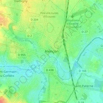
Name: Alençon topographic map, elevation, terrain.
Location: Alençon, Orne, Normandy, Metropolitan France, 61000, France (48.41031 0.06183 48.45183 0.12276)
Average elevation: 142 m
Minimum elevation: 127 m
Maximum elevation: 170 m
Other topographic maps
Click on a map to view its topography, its elevation and its terrain.
Menil Haton
France > Normandy > Orne > Valframbert
Menil Haton, Valframbert, Alençon, Orne, Normandy, Metropolitan France, 61250, France
Average elevation: 145 m