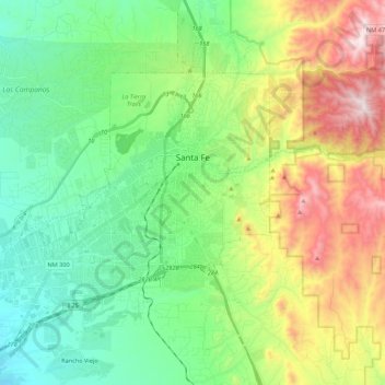
Santa Fe topographic map
Interactive map
Click on the map to display elevation.
About this map
Name: Santa Fe topographic map, elevation, terrain.
Average elevation: 2,222 m
Minimum elevation: 1,914 m
Maximum elevation: 2,862 m

Click on the map to display elevation.
Name: Santa Fe topographic map, elevation, terrain.
Average elevation: 2,222 m
Minimum elevation: 1,914 m
Maximum elevation: 2,862 m