
Batu Caves topographic map
Interactive map
Click on the map to display elevation.
About this map
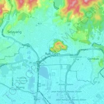
Name: Batu Caves topographic map, elevation, terrain.
Location: Batu Caves, Selangor, 68100, Malaysia (3.19802 101.64298 3.27802 101.72298)
Average elevation: 90 m
Minimum elevation: 32 m
Maximum elevation: 397 m
Other topographic maps
Click on a map to view its topography, its elevation and its terrain.
Lake Park Seri Gombak
Malaysia > Selangor > Batu Caves
Lake Park Seri Gombak, Taman Sri Gombak, Batu Caves, Selangor, 68100, Malaysia
Average elevation: 99 m