
Agua Suerada topographic map
Interactive map
Click on the map to display elevation.
About this map
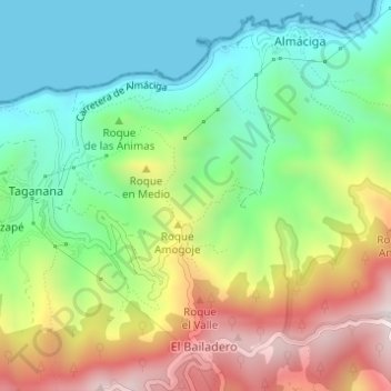
Name: Agua Suerada topographic map, elevation, terrain.
Average elevation: 284 m
Minimum elevation: 0 m
Maximum elevation: 745 m
Other topographic maps
Click on a map to view its topography, its elevation and its terrain.
Santa Cruz de Tenerife
Spain > Canary Islands > Santa Cruz de Tenerife
Santa Cruz de Tenerife, Canary Islands, 38004, Spain
Average elevation: 181 m
Macizo de Anaga
Spain > Canary Islands > Santa Cruz de Tenerife
Macizo de Anaga, Santa Cruz de Tenerife, Canary Islands, Spain
Average elevation: 201 m