
Udhagamandalam topographic map
Interactive map
Click on the map to display elevation.
Udhagamandalam
Ooty is situated in the Nilgiri Biosphere Reserve. Many of the forested areas and water bodies are off-limits to most visitors in order to protect this fragile ecosystem. Some areas of the Biosphere Reserve have been earmarked for tourism development, and steps are being undertaken to open these areas to visitors whilst conserving the area. It is situated at an altitude of 2,240 metres (7,350 feet) above sea level.
About this map
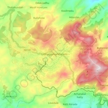
Name: Udhagamandalam topographic map, elevation, terrain.
Location: Udhagamandalam, Nilgiris, Tamil Nadu, 643001, India (11.37268 76.66305 11.45268 76.74305)
Average elevation: 2,234 m
Minimum elevation: 1,881 m
Maximum elevation: 2,622 m
Other topographic maps
Click on a map to view its topography, its elevation and its terrain.
Government Botanical Garden
India > Tamil Nadu > Udhagamandalam > Udhagamandalam
Average elevation: 2,325 m