
Lake and Peninsula topographic map
Interactive map
Click on the map to display elevation.
About this map
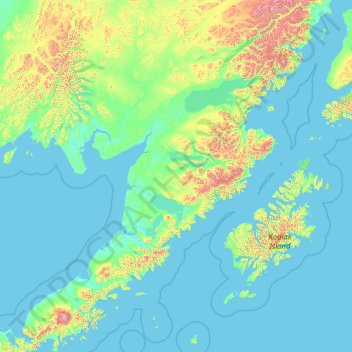
Name: Lake and Peninsula topographic map, elevation, terrain.
Location: Lake and Peninsula, Alaska, United States of America (55.62887 -159.90365 60.90854 -153.39320)
Average elevation: 151 m
Minimum elevation: -2 m
Maximum elevation: 2,791 m
Other topographic maps
Click on a map to view its topography, its elevation and its terrain.
Tundra
United States of America > Alaska > Tundra
Tundra, Unorganized Borough, Alaska, United States of America
Average elevation: 13 m
Noatak
United States of America > Alaska > Noatak
Noatak, Northwest Arctic, Alaska, United States of America
Average elevation: 23 m
Kodiak Island
United States of America > Alaska
Kodiak Island, Alaska, United States of America
Average elevation: 84 m
Bethel
United States of America > Alaska > Bethel
Bethel, Unorganized Borough, Alaska, 99559, United States of America
Average elevation: 11 m
Southeast Fairbanks
United States of America > Alaska > Copper Center
Southeast Fairbanks, Richardson Highway, Copper Center, Unorganized Borough, Alaska, United States of America
Average elevation: 856 m
Scott Glacier
United States of America > Alaska
Scott Glacier, Unorganized Borough, Alaska, United States of America
Average elevation: 914 m
North Slope
United States of America > Alaska
North Slope, Alaska, United States of America
Average elevation: 214 m