
Slope County topographic map
Interactive map
Click on the map to display elevation.
About this map
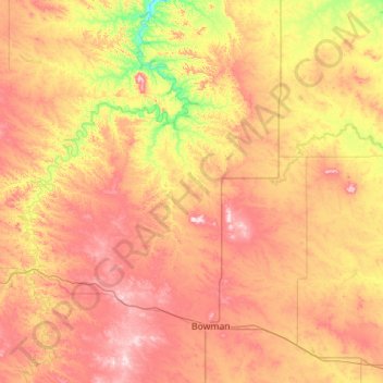
Name: Slope County topographic map, elevation, terrain.
Location: Slope County, North Dakota, United States (46.27931 -104.04610 46.63102 -102.92453)
Average elevation: 860 m
Minimum elevation: 700 m
Maximum elevation: 1,049 m
White Butte, the highest natural point in North Dakota at an elevation of 3506 ft (1062 m), is in southeast Slope County.
Other topographic maps
Click on a map to view its topography, its elevation and its terrain.
Bale Township
United States > North Dakota > Ransom County
Bale Township, Ransom County, North Dakota, United States
Average elevation: 387 m
Grand Forks
United States > North Dakota > Grand Forks County > Grand Forks
Grand Forks, Grand Forks County, North Dakota, United States
Average elevation: 255 m
Fargo
United States > North Dakota > Cass County > Fargo
Fargo, Cass County, North Dakota, 58102-4608, United States
Average elevation: 277 m
Bismarck
United States > North Dakota > Burleigh County > Bismarck
Bismarck, Burleigh County, North Dakota, United States
Average elevation: 523 m
Mountain
United States > North Dakota > Pembina County
Mountain, Pembina County, North Dakota, United States
Average elevation: 324 m