
Blansko topographic map
Interactive map
Click on the map to display elevation.
About this map
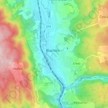
Name: Blansko topographic map, elevation, terrain.
Average elevation: 377 m
Minimum elevation: 268 m
Maximum elevation: 563 m
Blansko is located about 16 kilometres (10 mi) north of Brno. It lies in the Drahany Highlands. The highest point is the hill Bukovec with an altitude of 596 metres (1,955 ft). It is situated in the valley of the river Svitava, the majority of the town is situated on a slope above the left bank of the Svitava. The eastern part of the municipal territory lies in the Moravian Karst Protected Landscape Area.