
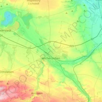
Aschersleben topographic map
Interactive map
Click on the map to display elevation.
About this map
Name: Aschersleben topographic map, elevation, terrain.
Average elevation: 143 m
Minimum elevation: 54 m
Maximum elevation: 306 m
Other topographic maps
Click on a map to view its topography, its elevation and its terrain.
Athensleben
Deutschland > Sachsen-Anhalt > Salzlandkreis > Staßfurt
Athensleben, Löderburg, Staßfurt, Salzlandkreis, Sachsen-Anhalt, 39446, Deutschland
Average elevation: 69 m
Förderstedt
Deutschland > Sachsen-Anhalt > Salzlandkreis
Förderstedt, Staßfurt, Salzlandkreis, Sachsen-Anhalt, 39443, Deutschland
Average elevation: 79 m
Neundorf (Anhalt)
Deutschland > Sachsen-Anhalt > Salzlandkreis > Staßfurt
Neundorf (Anhalt), Staßfurt, Salzlandkreis, Sachsen-Anhalt, Deutschland
Average elevation: 99 m
Staßfurt
Deutschland > Sachsen-Anhalt > Salzlandkreis
Staßfurt, Salzlandkreis, Sachsen-Anhalt, Deutschland
Average elevation: 86 m
Güsten
Deutschland > Sachsen-Anhalt > Salzlandkreis
Güsten, Saale-Wipper, Salzlandkreis, Sachsen-Anhalt, 39439, Deutschland
Average elevation: 94 m
Amesdorf
Deutschland > Sachsen-Anhalt > Salzlandkreis > Güsten
Amesdorf, Güsten, Saale-Wipper, Salzlandkreis, Sachsen-Anhalt, 39439, Deutschland
Average elevation: 94 m
Plötzkau
Deutschland > Sachsen-Anhalt > Salzlandkreis
Plötzkau, Saale-Wipper, Salzlandkreis, Sachsen-Anhalt, Deutschland
Average elevation: 84 m
Schönebeck (Elbe)
Deutschland > Sachsen-Anhalt > Salzlandkreis
Schönebeck (Elbe), Salzlandkreis, Sachsen-Anhalt, Deutschland
Average elevation: 57 m
Bernburg (Saale)
Deutschland > Sachsen-Anhalt > Salzlandkreis
Bernburg (Saale), Salzlandkreis, Sachsen-Anhalt, 06406, Deutschland
Average elevation: 78 m