
Wales topographic map
Interactive map
Click on the map to display elevation.
About this map
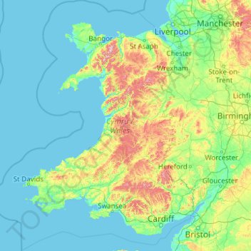
Name: Wales topographic map, elevation, terrain.
Location: Wales, United Kingdom (51.22903 -5.80773 53.63500 -2.64986)
Average elevation: 99 m
Minimum elevation: 0 m
Maximum elevation: 1,001 m
Much of Wales's diverse landscape is mountainous, particularly in the north and central regions. The mountains were shaped during the last ice age, the Devensian glaciation. The highest mountains in Wales are in Snowdonia (Eryri), of which five are over 1,000 m (3,300 ft). The highest of these is Snowdon (Yr Wyddfa), at 1,085 m (3,560 ft). The 14 Welsh mountains, or 15 if including Carnedd Gwenllian – often discounted because of its low topographic prominence – over 3,000 feet (910 metres) high are known collectively as the Welsh 3000s and are located in a small area in the north-west. The highest outside the 3000s is Aran Fawddwy, at 905 metres (2,969 feet), in the south of Snowdonia. The Brecon Beacons (Bannau Brycheiniog) are in the south (highest point Pen y Fan, at 886 metres (2,907 feet)), and are joined by the Cambrian Mountains in Mid Wales (highest point Pumlumon, at 752 metres (2,467 feet)).
Other topographic maps
Click on a map to view its topography, its elevation and its terrain.
Manchester
Manchester, Greater Manchester, England, United Kingdom
Average elevation: 66 m
South Lanarkshire
South Lanarkshire, Scotland, United Kingdom
Average elevation: 289 m
Aberfoyle
United Kingdom > Scotland > Stirling
Aberfoyle, Stirling, Scotland, FK8 3UH, United Kingdom
Average elevation: 129 m
Wallsend
United Kingdom > England > North Tyneside
Wallsend, North Tyneside, North of Tyne, England, NE28 8QS, United Kingdom
Average elevation: 41 m
Mullion
United Kingdom > England > Cornwall
Mullion, Cornwall, England, United Kingdom
Average elevation: 45 m
Siston
United Kingdom > England > South Gloucestershire
Siston, South Gloucestershire, West of England, England, United Kingdom
Average elevation: 80 m
Colsterworth
United Kingdom > England > Lincolnshire > South Kesteven
Colsterworth, South Kesteven, Lincolnshire, England, United Kingdom
Average elevation: 114 m
Coleby
United Kingdom > England > Lincolnshire > North Kesteven
Coleby, North Kesteven, Lincolnshire, England, LN5 0AG, United Kingdom
Average elevation: 50 m
Selkirk
United Kingdom > Scotland > Scottish Borders
Selkirk, Scottish Borders, Scotland, TD7 4BT, United Kingdom
Average elevation: 226 m
Metropolitan Borough of Solihull
Metropolitan Borough of Solihull, West Midlands Combined Authority, England, United Kingdom
Average elevation: 119 m
Dowlish Ford
United Kingdom > England > Somerset > Ilminster
Dowlish Ford, Ilminster, Somerset, England, TA19 0PE, United Kingdom
Average elevation: 67 m
Axminster
United Kingdom > England > Devon > East Devon
Axminster, East Devon, Devon, England, United Kingdom
Average elevation: 86 m
Cowdenbeath
United Kingdom > Scotland > Fife
Cowdenbeath, Fife, Scotland, KY4 9NH, United Kingdom
Average elevation: 130 m
Aylesbury
United Kingdom > England > Buckinghamshire
Aylesbury, Buckinghamshire, England, United Kingdom
Average elevation: 85 m
Langport
United Kingdom > England > Somerset
Langport, Somerset, England, United Kingdom
Average elevation: 18 m
Granby
United Kingdom > England > Nottinghamshire > Rushcliffe
Granby, Sutton, Rushcliffe, Nottinghamshire, England, United Kingdom
Average elevation: 32 m
Newtownards
United Kingdom > Northern Ireland > County Down
Newtownards, County Down, Northern Ireland, BT23 4FA, United Kingdom
Average elevation: 50 m
Penmachno
United Kingdom > Wales > Conwy
Penmachno, Conwy, Wales, LL24 0TY, United Kingdom
Average elevation: 269 m
Alston
United Kingdom > England > Westmorland and Furness
Alston, Westmorland and Furness, England, CA9 3RF, United Kingdom
Average elevation: 404 m
Milton
United Kingdom > England > Cumberland > Brampton
Milton, Brampton, Cumberland, England, CA8 1HX, United Kingdom
Average elevation: 139 m
Biggin CP
United Kingdom > England > Derbyshire > Derbyshire Dales
Biggin CP, Derbyshire Dales, Derbyshire, England, United Kingdom
Average elevation: 188 m
Heathcote
United Kingdom > England > Derbyshire > Derbyshire Dales
Heathcote, Derbyshire Dales, Derbyshire, England, SK17 0AY, United Kingdom
Average elevation: 309 m
Llangyfelach
United Kingdom > Wales > Swansea > Swansea
Llangyfelach, Swansea, Wales, United Kingdom
Average elevation: 94 m
Sutton
United Kingdom > England > Kingston upon Hull
Sutton, Kingston upon Hull, England, HU7 4UF, United Kingdom
Average elevation: 3 m
Craster
United Kingdom > England > Northumberland
Craster, Northumberland, North of Tyne, England, United Kingdom
Average elevation: 16 m
Richmond Park
United Kingdom > England > London
Richmond Park, London Borough of Richmond upon Thames, London, Greater London, England, United Kingdom
Average elevation: 26 m
Harrold
United Kingdom > England > Bedford
Harrold, Bedford, England, MK43 7DA, United Kingdom
Average elevation: 66 m
Huddersfield
United Kingdom > England > Kirklees
Huddersfield, Kirklees, West Yorkshire, England, HD1 2AA, United Kingdom
Average elevation: 145 m
Oxshott
United Kingdom > England > Surrey > Elmbridge
Oxshott, Elmbridge, Surrey, England, KT22 0SN, United Kingdom
Average elevation: 47 m
Tanyfron
United Kingdom > Wales > Wrexham
Tanyfron, Wrexham, Wales, LL11 5SB, United Kingdom
Average elevation: 178 m
St Andrews
United Kingdom > Scotland > Fife
St Andrews, Fife, Scotland, KY16 9PA, United Kingdom
Average elevation: 38 m
Bagpath
United Kingdom > England > Gloucestershire > Cotswold District
Bagpath, Kingscote, Cotswold District, Gloucestershire, England, GL8 8YG, United Kingdom
Average elevation: 198 m
Baslow
United Kingdom > England > Derbyshire > Derbyshire Dales
Baslow, Derbyshire Dales, Derbyshire, England, DE45 1HS, United Kingdom
Average elevation: 180 m
Haverfordwest
United Kingdom > Wales > Pembrokeshire
Haverfordwest, Pembrokeshire, Wales, United Kingdom
Average elevation: 32 m
Cow Down
United Kingdom > England > Hampshire > Test Valley
Cow Down, Test Valley, Hampshire, England, SP11 9HE, United Kingdom
Average elevation: 193 m
Hadstone Carrs
United Kingdom > England > Northumberland > Togston
Hadstone Carrs, Togston, Northumberland, North of Tyne, England, United Kingdom
Average elevation: 3 m
Acklington
United Kingdom > England > Northumberland
Acklington, Northumberland, North of Tyne, England, United Kingdom
Average elevation: 36 m
Twatt
United Kingdom > Scotland > Orkney Islands
Twatt, Orkney Islands, Scotland, KW17 2LN, United Kingdom
Average elevation: 32 m
Kidsgrove
United Kingdom > England > Staffordshire > Kidsgrove
Kidsgrove, Newcastle-under-Lyme, Staffordshire, England, United Kingdom
Average elevation: 161 m
Bentley Heath
United Kingdom > England > Metropolitan Borough of Solihull
Bentley Heath, Metropolitan Borough of Solihull, West Midlands Combined Authority, England, B93 9BL, United Kingdom
Average elevation: 126 m
Blackpool
United Kingdom > England > Borough of Blackpool
Blackpool, Borough of Blackpool, England, FY1 1DL, United Kingdom
Average elevation: 7 m
Wingfield
United Kingdom > England > Suffolk > Mid Suffolk
Wingfield, Mid Suffolk, Suffolk, England, United Kingdom
Average elevation: 46 m
Perth and Kinross
Perth and Kinross, Scotland, United Kingdom
Average elevation: 338 m
Marlow
United Kingdom > England > Buckinghamshire
Marlow, Buckinghamshire, England, United Kingdom
Average elevation: 51 m
Hanley
United Kingdom > England > Stoke-on-Trent
Hanley, Stoke-on-Trent, England, ST1 1LD, United Kingdom
Average elevation: 154 m
Caddington
United Kingdom > England > Central Bedfordshire
Caddington, Central Bedfordshire, England, United Kingdom
Average elevation: 165 m