
Chaillot topographic map
Interactive map
Click on the map to display elevation.
About this map
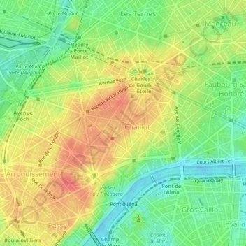
Name: Chaillot topographic map, elevation, terrain.
Average elevation: 55 m
Minimum elevation: 27 m
Maximum elevation: 83 m
Other topographic maps
Click on a map to view its topography, its elevation and its terrain.
Place Igor Stravinsky
France > Ile-de-France > Paris
Place Igor Stravinsky, 4th Arrondissement, Paris, Ile-de-France, Metropolitan France, 75004, France
Average elevation: 47 m
Gros-Caillou
France > Ile-de-France > Paris
Gros-Caillou, 7th Arrondissement, Paris, Ile-de-France, Metropolitan France, 75007, France
Average elevation: 47 m
Enfants Rouges
France > Ile-de-France > Paris
Enfants Rouges, 3rd Arrondissement, Paris, Ile-de-France, Metropolitan France, 75003, France
Average elevation: 51 m
Enjöy
France > Ile-de-France > Paris
Enjöy, Passage du Havre, Chaussée-d'Antin, 9th Arrondissement, Paris, Ile-de-France, Metropolitan France, 75009, France
Average elevation: 56 m